

Op-Ed: Why Remote Inspection Supports Operational Imperatives
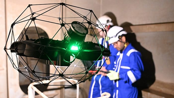
To maintain the global fleet to the required standards throughout a vessel’s lifecycle, shipowners and operators must comply with established Classification rules and regulations, ensuring vessels are equipped to meet new and future operational standards. Across the time available to survey a ship the surveyor has to utilise their expertise and experience to focus on the most important areas of the structure. New ‘remote’ technology, enabled by AI, can assist a survey, helping it be ever more comprehensive and effective.
And, right now, remote surveys are also helping address operational challenges. The ongoing conflict in the Middle East and the Red Sea is placing extraordinary strain on global maritime operations. According to the International Maritime Organization (IMO), which has condemned the latest attacks on ships transiting the Strait of Hormuz, nearly 6,000 seafarers remain stranded on board vessels unable to depart the Persian Gulf safely. Amid this complex web of geopolitical volatility, one area of growing concern is the impact of sustained disruption on the health and condition of the global fleet, as vessels may begin to fall behind on their classification requirements.
The impact of this ongoing disruption is evident. Diversion around the Cape of Good Hope adds 10 to 14 days of voyage time on average for Asia-Europe routes, placing additional strain on ships, which then leads to heightened maintenance requirements across shipowners' fleets. Port call delays at regional hubs have also increased significantly, at a time when surveyors face major restrictions on their ability to travel. Remote surveys can provide support when physical access is difficult, not safe or impossible.
The case for smarter inspection is not only operational. Beyond the mounting pressures of cost, scheduling and fleet availability lies an ongoing concern: the safety of the people who carry out these surveys. Nowhere is that risk more acute than in the enclosed spaces that surveyors and crew may be required to enter.
The hidden safety risks of enclosed spaces
Despite decades of progress in the development of regulatory frameworks and training programmes, the hidden danger posed by enclosed spaces continues to claim lives. A recent report from the International Bulk Terminals Association (IBTA) outlines the scale of the threat: between 2000 and 2024, 1,010 ship and shore workers died in enclosed space-related incidents, which represents an average of 40 deaths per year; of those who died, some 69 percent were crew members.
This trend is particularly relevant to survey engagements. Surveyors are regularly required to enter confined spaces that present a range of often hidden threats: extreme heat, with temperatures reaching 50 degrees Celsius in the Middle East, high humidity, and toxic gas pockets generated by bacterial activity in mud and ballast water.
When it comes to traditional survey inspections, each confined space entry requires a team of up to seven individuals, including surveyors, crew members on deck and safety coordinators. However, by leveraging advanced survey methods, the industry can significantly reduce both the number of entries into potentially hazardous areas and the total time spent within them.
Remote inspection techniques advances tech-enabled survey
Inspections of ballast tanks, cargo holds and other confined spaces are essential to maintaining structural integrity, yet preparing hazardous areas for entry can lead to days or even weeks of dry-dock downtime. In today's geopolitical landscape, smarter survey techniques have advanced from a novel innovation to an operational imperative.
To facilitate safer and more effective surveys, Bureau Veritas Marine & Offshore (BV) has developed a unique approach to Remote Inspection Techniques (RIT), an advanced inspection methodology that combines specialist surveyor expertise with drone-enabled inspections alongside AI-supported data processing and analysis.
Unlike traditional remote surveys, RIT inspections are performed onboard by BV-qualified surveyors, trained specifically by vessel type, ensuring inspections are conducted by subject matter experts with a detailed operational understanding of the asset. These specialists deploy advanced drone and Unmanned Aerial Vehicle (UAV) technology to inspect confined and hazardous spaces without the need for human entry.
A full vessel RIT engagement can generate thousands of minutes of inspection footage from ballast tanks, cargo holds and structural areas. This data is then processed using BV's market-first Augmented Surveyor 3D (AGS 3D) capabilities and AI-supported analysis to identify, categorize and standardize inspection findings, which are then validated by a qualified surveyor, enabling the identification of potential structural weaknesses with an unprecedented level of depth.
By utilizing BV's RIT methodology, the maritime industry can reduce entries into confined spaces by 60 to 70 percent, delivering a significant improvement in surveyor and crew safety. RIT also reduces the need for scaffolding, rope-access teams and extended confined-space preparation, lowering inspection costs, shortening dry-dock times and improving vessel availability. In addition, faster access to standardized inspection data supports earlier maintenance planning, predictable OPEX and reduced hire-off exposure.
A global network, built for resilience
In 2025, BV launched its first dedicated RIT center, offering clients coverage 24 hours a day, seven days a week. Seven operational centers are now established, including in France, Angola, Greece, and Denmark, with more centers soon to be launched, creating a global RIT resource for the Marine and Offshore industry. BV has also published RIT guidelines that establish roles, responsibilities, and procedures to support shipowners, service suppliers, and surveyors in adopting the technique.
The technology continues to evolve. Following a pilot project on an FPSO unit in West Africa, involving the drone-based inspection of two water ballast tanks, BV has expanded its AGS 3D across a growing portfolio of vessels and offshore assets.The technology now transforms visual inspection data, captured via high-resolution cameras and LiDAR sensors, into a detailed 3D digital model with AI-enhanced corrosion analytics, giving operators a unified, accurate view of asset condition to guide decision-making.
To date, AGS 3D has been deployed on more than 90 tanks across FPSOs, FPUs and FSOs in Angola, Nigeria and Congo. These projects have delivered measurable benefits, including a 57% reduction in inspection lead times compared with traditional methods, a 54% reduction in costs versus rope-access and scaffolding-based approaches, and a 62% man-hour reduction.

that matters most
Get the latest maritime news delivered to your inbox daily.
Geopolitical volatility may be beyond the industry's control, but the condition of the global fleet is not. With solutions like RIT and AGS 3D, classification can remain agile, surveyors can stay safe, and the world's vessels can continue to meet the highest safety and performance standards.
Christophe Chauviere is SVP of Technical & Operations Excellence at Bureau Veritas Marine & Offshore.
The opinions expressed herein are the author's and not necessarily those of The Maritime Executive.