
New Warning of Numerous Reports of Global Navigation and AIS Interference
UK Maritime Trade Operations issued a new advisory after receiving an increased number of reports of interference that is impacting the Global Navigation Satellite System (GNSS) as well as data on AIS displays. It comes as Qatar continues to work to repair a “technical fault in GPS,” which it first reported over the weekend.
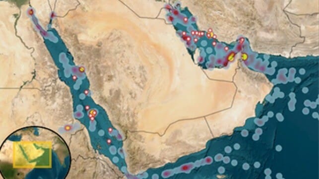
According to the latest updates, there has been a significant increase in the number of reports that started on October 3 and have continued through today, October 7. UKMTO said the reports are concentrated in the areas around Bandar-e-Pars (Iran), the Strait of Hormuz, and Port Sudan. It warns that the incidents have increased compared to last week, advising ships to use increased caution.
As part of the ongoing issue, they are also warning ships that vessels are observing “AIS Speed anomalies.” The speed irregularities are being consistently observed throughout the Gulf, Port Sudan, and Suez Canal areas, says UKMTO.
The Ministry of Transport of Qatar also cited the issues with GPS and took the unusual step on October 4 of telling all maritime vessel owners that they were “obliged to temporarily suspend maritime navigation activities." It initially said the suspension would remain in effect till the technical fault was cleared. Yesterday, the Ministry, however, partially removed the ban, saying navigation activities were permitted during daytime hours. Smaller vessels, including pleasure crafts, tourism vessels, and fishing, however, were still being told to return to port before sunset and not to sail further than 12 nautical miles.
As the problem persists, UKMTO also reiterated a May 2025 warning from the Joint Maritime Information Center, which had advised shipping in the Red Sea and Strait of Hormuz not to solely rely on electronic navigation systems and autopilots. They also said it would be prudent for vessels to consider using traditional non-electronic means of position-fixing to cross-check the vessel’s position.

that matters most
Get the latest maritime news delivered to your inbox daily.
JMIC’s warning came after the containership MSC Antonia grounded in the Red Sea while it was bound for Jeddah, Saudi Arabia. The incident was widely believed to be the result of GPS jamming, and the ship spent weeks aground, only leaving Jeddah in late June after grounding on May 10. During the incident, GPS spoofing frequently changed the ship’s reported position.
Interference of electronic systems is considered to be a “routine issue” in the region ranging from the Red Sea to the Arabian Gulf. Shipping has learned to deal with them and adjust operations, but the authorities continue to warn of the dangers. So far, no one has been able to pinpoint the source of the latest problems in Qatar or across the region.
