
China Surveys Vietnamese Naval Base Using U.S. Satellite Data
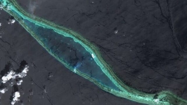
Over the past year, Vietnam has accelerated its land reclamation program in the Spratly Islands, building out acreage and enlarging its military bases at a faster pace than any other claimant. At its largest facility on Barque Canada Reef, it has dug out a ship channel large enough to accommodate the largest existing destroyers and cruisers, according to a new paper released by China's Ministry of Natural Resources.
The paper, published in the latest edition of the Chinese-language Journal of Tropical Oceanography, describes a method to combine free data from American and European satellites to precisely chart out the depth of the channel - without the need for on-site surveying or permission from the base's operator. NASA's ICESat-2 satellite has laser sensing capabilities that can reach down to 30 meters below the surface, enabling depth detection with high precision. When combined with high-resolution optical imaging from the EU's Sentinel satellite constellation, this laser data enables unauthorized charting of sensitive installations like Vietnam's newly-built naval base.
According to the ministry's measurements, the channel has enough depth to accommodate warships up to the size of the PLA Navy's Type 055 destroyers, which draw about 22 feet of water. This is significantly less than would be needed for the equivalent U.S. Navy vessels, the Ticonderoga-class and the Arleigh Burke-class, which both require more than 30 feet of depth.
The paper also assessed the scale and speed of the land reclamation campaign. Vietnam appears to have added nearly 500 acres to Barque Canada Reef in just two years, and the harbor was added just last year. Coauthor Fu Dongyang wrote that the changes "have profoundly reshaped [the reef's] topography," but there is still room to grow. The shoal has about 16,000 acres of natural coral flats that could be converted to support strategic military uses, as China has done with the reef flats at nearby Mischief Reef, Fiery Cross Reef and Subi Reef.

that matters most
Get the latest maritime news delivered to your inbox daily.
Vietnam has been clear about the purpose of the expansion. The Spratly Islands are contested by Vietnam, China, the Philippines, Taiwan and Malaysia, with the largest share located within the Philippine Exclusive Economic Zone (EEZ). China claims ownership over the entirety of the archipelago under its "nine-dash line" policy, and has the most extensive military presence.
For Vietnam, the bases provide a security perimeter far from home. “We will resort to every means possible to make sure we can defend and safeguard our legitimate interests in the [South China Sea]," Vietnamese foreign policy director Le Dinh Tinh told the Washington Post last year.
