
UN to Use High-Tech Satellites to Detect Methane Emissions
Seeking to accelerate the implementation of the Global Methane Pledge launched at last year’s UN Climate Change Conference, the UN Environmental Programme (UNEP) announced the launch of a high-tech, satellite-based global methane detection system. Calling it the first public global system connecting methane detection to a notification process, UNEP says the system will be used to notify governments, companies, and operators about large methane sources to support expanded mitigation efforts.
The Methane Alert and Response System (MARS) was announced today at the 27th United Nations Climate Change Conference (COP27). It will use state-of-the-art satellite data to identify major emission events. While the developers said it will begin with very large point sources from the energy sector, they noted that MARS will integrate data from the rapidly expanding system of methane-detecting satellites to include lower-emitting area sources and more frequent detection. They gradually expect to add data to smaller sources, such as coal, waste, livestock, and rice, all in support of the implementation of the Global Methane Pledge.
“We are seeing methane emissions increase at an accelerated rate,” said Dr. Kelly Levin, Chief of Science, Data and Systems Change at the Bezos Earth Fund, one of the initial funding sources for the development of MARS. “With this initiative, armed with greater data and transparency, companies and governments can make greater strides to reduce methane emissions and civil society can keep them accountable to their promises.”
This effort to further crack down on methane emissions comes as the maritime industry is rapidly accelerating its adoption of liquified natural gas as a fuel source for ships. Environmentalists have been vocal critics of the shipping industry’s use of LNG saying that it is contributing to the increases in methane emissions, while trade groups such as SEA-LNG argue that the newest generation of engines is reducing and eliminating methane slip (the release of unburnt methane).
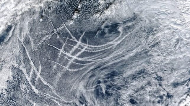
Scientists have previously shown that satellites can be an effective tool in tracking ships’ emissions. NASA, for example, last month released the results of its analysis of satellite images showing the trails left crossing the world’s oceans and outside ports from ships. The scientists were able to note a clear decline which they attributed to the adoption of low-sulfur fuel regulations.
“Reducing methane emissions can make a big and rapid difference, as this gas leaves the atmosphere far quicker than carbon dioxide,” said Inger Andersen, Executive Director of UNEP. “The Methane Alert and Response System is a big step in helping governments and companies deliver on this important short-term climate goal.”

that matters most
Get the latest maritime news delivered to your inbox daily.
The Methane Alert and Response System will use data from global mapping satellites to identify very large methane plumes and methane hot spots and data from high-resolution satellites to then attribute the emissions to a specific source. UNEP says it will use the information to notify governments and companies about the emissions, either directly or through partners, so that the responsible entity can take appropriate action. UNEP says it will continue to monitor the event location and will also make the data and analysis available to the public between 45 and 75 days after detection.
MARS will be implemented with partners including the International Energy Agency, and the UNEP-hosted Climate and Clean Air Coalition. Initial funding to develop the system came from the European Commission, the U.S. Government, Global Methane Hub, and the Bezos Earth Fund. The partners will also be available to provide technical or advisory services such as help in assessing mitigation opportunities.