
Super Typhoon Yutu Hits U.S. Pacific Territory
Super Typhoon Yutu struck the Northern Mariana Islands as a Category 5 storm on Wednesday with winds of up to 180 miles per hour, making it the most powerful storm of the year and one of the most powerful ever to make landfall in a United States territory. Its eyewall passed directly over the island of Tinian and touched the southern edge of Saipan, bringing heavy rains and a storm surge of up to 20 feet.
"[Yutu is] one of the most intense tropical cyclones we’ve observed worldwide in the modern record," said FEMA official Michael Lowry in a social media post. "This is a historically significant event."
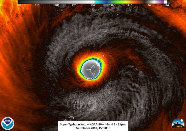
Yutu's eyewall over Tinian and Saipan (NOAA)

Damage in Tinian (Esther Muna / Twitter)
Yutu intensified rapidly overnight, growing from a 75-mph Category 1 storm to a 180-mph Category 5 in the span of just 36 hours. Its central pressure plummeted from 974 mB to less than 900 mB over the same period.
The National Weather Service's Guam office told the local Daily Post that its instruments in Saipan did not survive the storm. "We were amazed that the cell phones were still working, but now it seems that's stopped," said NWS meteorologist Paul Stanko.
The islands of Rota, Tinian, Saipan and Guam are still recovering from Typhoon Mangkhut, which passed through in September on its way to the Philippines and Hong Kong.

that matters most
Get the latest maritime news delivered to your inbox daily.
The U.S. Navy's Joint Typhoon Warning Center predicts that Yutu will carve a path west-northwest across the Pacific, and it is expected to weaken slightly over the course of the week. Its track is uncertain past the 120-hour forecast. Taiwan's Central Weather Bureau expects that it will turn to the north and will not threaten Taiwan's population, but other modelers warn that the typhoon could potentially end up anywhere between Luzon and Okinawa.
Tinian in the Northern Mariana Islands is taking a direct hit by Super #Typhoon #Yutu. JTWC estimates the max sustained winds are now at 155 KTS (178 MPH) with gusts to a staggering 190 KTS (219 MPH)! (JMA Himawari imagery) pic.twitter.com/qf6SpLx9S9
— NASA SPoRT (@NASA_SPoRT) October 24, 2018
