
Hurricane Michael Disrupts Cruise Itineraries, Offshore Operations
Hurricane Michael continued to strengthen on Tuesday as it headed for the Florida Panhandle, where it is expected to make landfall on Wednesday morning. Maximum windspeeds increased to about 105 knots, enough to make Michael a Category 3 storm.
The storm's intensity increased Monday despite wind shear of 20 knots at upper elevations, a "most unusual" anomoly that "defies traditional logic," according to the National Hurricane Center. Strong wind shear usually disrupts a cyclone by pulling heat and moisture out of its core and tilting the storm sideways. Michael's size may have made it more resistant to shear conditions, NHC suggested, allowing it to sustain its intensity as it moved into the Gulf's warm waters. Sea surface temperatures along Michael's path are about one to two degrees C above average for this time of year, putting the water above the 28 C lower limit for creating and sustaining cyclones.
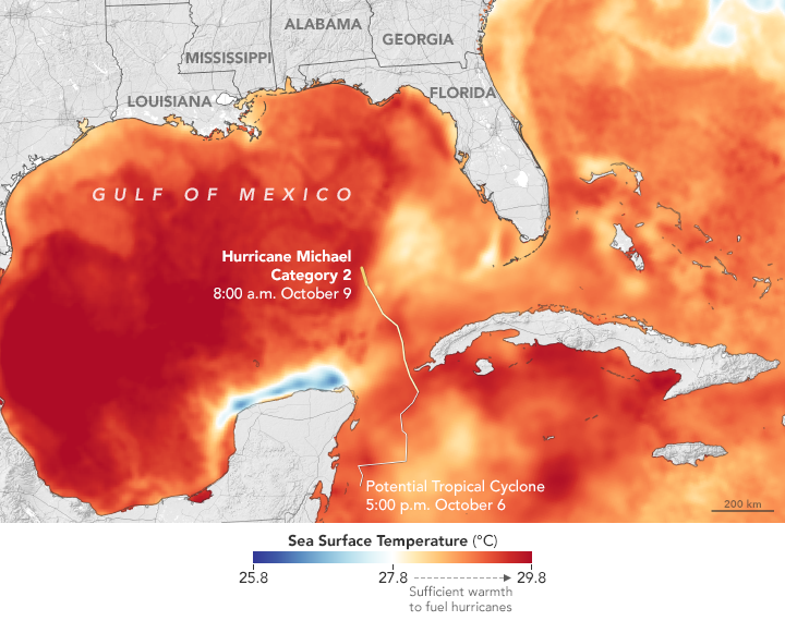
Courtesy NASA Earth Observatory
Disrupted operations
The storm has already disrupted operations for cruise lines. Multiple cruise ships have been forced to alter itineraries and cancel port calls: on Tuesday, Carnival Miracle canceled a call at Cozumel; Carnival Paradise delayed calls in Cozumel and Grand Caymen by taking a reverse itinerary; Carnival Glory canceled a call at Grand Cayman; Carnival Freedom skipped a call at Mahogany Bay, Hunduras; and Carnival Triumph and Carnival Victory are sailing their itineraries in reverse order to put them out of the storm's path. On Tuesday, the Norwegian Getaway headed for Falmouth, Jamaica instead of Roatan, Honduras, and will substitute Grand Cayman instead of Costa Maya on Wednesday.
A passenger aboard the Royal Caribbean vessel Empress of the Seas reported Monday night that the vessel encountered gale conditions on the storm's outer bands off Isla de la Juventud, Cuba. He told CNN that the vessel's arrival in Havana had been delayed by the storm, and said that some of the passengers had experienced seasickness.
Separately, the Bureau of Safety and Environmental Enforcement released new numbers on rig shutdowns Tuesday, and the numbers show that offshore operators are moving to reduce risk ahead of the storm. 75 offshore production platforms have now been evacuated, up from 10 on Monday. Eight DP rigs have relocated to areas outside of the storm's path, representing half the total presently working in the Gulf. In addition, 40 percent of the Gulf's oil production capacity (or 670,000 bpd) and nearly 30 percent of its gas (725 mmcfd) have been shut in as a precautionary measure.
Shoreside effects
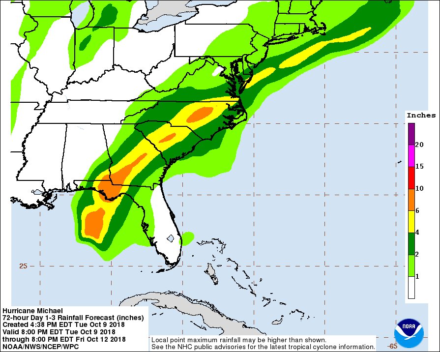
Hurricane Michael is expected to bring considerable damage to the Florida Panhandle. It is a wide, fast-moving storm, with hurricane-force winds covering a swath of 45 miles outwards from its center. It is expected to bring a dangerous storm surge of 9-13 feet to the stretch of Florida's coastline between Mexico Beach and Keaton Beach, near Tallahassee. The Panhandle, southeast Alabama, and parts of Georgia could see 4-8 inches of rain, with isolated pockets receiving up to 12 inches.
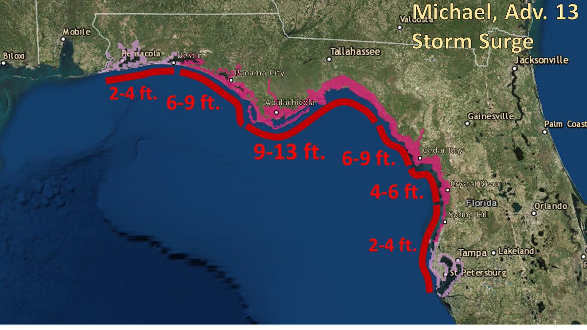
Graphic courtesy National Hurricane Center
State and federal officials are encouraging citizens in the most affected communities to heed evacuation orders, which are in effect for parts of 18 Florida counties. "Hurricane Michael is forecast to be the most destructive storm to hit the Florida Panhandle in decades," said Florida Gov. Rick Scott on Tuesday. "It will be life-threatening and extremely dangerous. You cannot hide from this storm."
As Michael continues inland, it will drench areas that are still recovering from the rain and flooding brought by Hurricane Florence. Georgia, the Carolinas and southern Virginia are set to receive 3-6 inches of rain, with isolated pockets receiving up to eight inches.
“Because of the damage caused by Hurricane Florence and the fact that there’s still some standing water in places, we have to be that much more alert about the damage that Hurricane Michael could do,” said North Carolina Gov. Roy Cooper at a news conference on Tuesday. "We know we have to be ready."
Coast Guard prepares for port closures
The U.S. Coast Guard is preparing for port closures to mitigate risk from Hurricane Michael. On Tuesday, Sector Mobile set port condition Yankee (vessel traffic controlled) for the following ports and waterways in anticipation of tropical storm force winds:
Gulf Intracoastal Waterway west of Perdido Pass
Port of Gulfport
Port of Mobile
Port of Pascagoula
The USCG has set port condition Zulu (port closed) for northern Florida Gulf Coast ports, which will experience the worst of the storm's effects. All commercial port operations between Cedar Key and Tarpon Springs are now suspended. The waterways and facilities affected include:
Gulf Intracoastal Waterway east of Perdido Pass
Port of Panama City
Port of Pensacola

that matters most
Get the latest maritime news delivered to your inbox daily.
"Coast Guard Station Yankeetown crew members and all of our crews along Florida's Gulf Coast are preparing early for the hurricane," said Cmdr. William Walsh, the Sector St. Petersburg deputy commander. "Use this time before the storm to save your property, but more importantly your life."
To the northeast, the Coast Guard has set port condition X-Ray (storm expected within 48 hours) for ports in Georgia and South Carolina. All ocean-going vessels and barges over 500 GT in the affected ports must make plans to depart at least 24 hours before the storm or ask the Captain of the Port for a waiver.