
FarSounder and NAVTOR Announce Partnership on Ocean Technology
[By: Navtor]
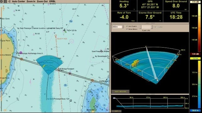
FarSounder and NAVTOR are proud to announce a new partnership. FarSounder now includes support for NAVTOR official ENC chart data in their base software package to its customers.
On the ever-going journey in protecting the ecosystem and keeping vessels and passengers safe, FarSounder and NAVTOR are the perfect match to make an impact! We share the same core goals of preserving the oceans safe through innovation and technology while simultaneously focusing on the customer. Through this partnership, we are excited to be exploring the many ways we can work together to achieve this goal.
A safer look ahead
NAVTOR prides itself on creating e-Navigation tools that are safe, simple, and more efficient. Similarly, FarSounder’s Argos 3D Forward Looking Sonar provides safe navigation by detecting many ocean obstacles via an easy-to-understand user interface. This partnership brings an impactful software update for the Argos technology.
“By implementing the NAVTOR ECDIS Kernel in the FarSounder platform, we bring official electronic navigational chart display (ENC’s) to the FarSounder customers for optimal safety, awareness and flexibility. A significant benefit from this partnership is the integration with NAVTOR’s trusted e-Navigation ecosystem. The cloud-based data distribution keeps everything up to date, with the latest charts and publications delivered seamlessly to the vessel. For vessels with an ECDIS installed, there is now the option to have matching map displays on both their ECDIS and FarSounder radar system,” says Bjørn Kristian Sæstad, CBDO OEM/SDK at NAVTOR.
Toward safer voyages, together.
“In this release, users will not only have support for NAVTOR ENC chart data included, but they will also be able to bring up Automatic Identification System (AIS) targets and Automatic Radar Plotting Aid (ARPA) targets in the Chart Viewer,” says Cheryl M. Zimmerman, CEO at Farsounder. “Support for new NMEA message types associated with AIS and ARPA targets has been added and are easily displayed on the FarSounder stand-alone system. With this additional information, customers have a complete understanding of their surroundings on one screen.”
This journey has just begun, and both FarSounder and NAVTOR cannot wait to see where this partnership takes them in the direction of protecting the ocean and ensuring the best experience for their customers!
The products and services herein described in this press release are not endorsed by The Maritime Executive.
