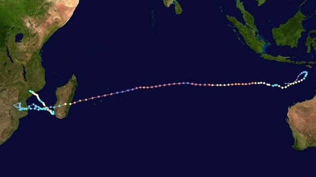
Record-Setting Cyclone Freddy Makes Third Landfall

Over the weekend, Tropical Cyclone Freddy made its third and final landfall in central Mozambique. This is the cyclone’s third landfall in the area: it arrived on the east coast of Madagascar on February 21 and transited over the southern coast of Mozambique three days later. The first landfall killed 17 and destroyed over 14,000 homes in Madagascar, while the second left 10 people dead and destroyed over 28,000 homes in Mozambique.
Over the course of the last week, Freddy gradually intensified into a tropical cyclone once again over the Mozambique Channel before making a third landfall in the port town of Quelimane, Mozambique on Saturday. Meteorologists have warned that Freddy is a slow-moving cyclone and likely to pick up more moisture over the sea, bringing heavy rainfall. The downpour expected will be in the range of 200mm- 500mm depending on the area.
The World Meteorological Organization (WMO) has described cyclone Freddy as a remarkable storm. It has been swirling for 35 days, crossed the entire South Indian Ocean and traveled more than 8,000 kilometers, from the northwest coast of Australia to Southern Africa.
“This kind of super zonal track is very rare. The most recent recorded cases were Tropical Cyclones Leon-Eline and Hudah, both in 2000, which like 2023 was a La Nina year,” commented WMO.
Preliminary results show that Freddy is likely to have established a new record as the longest-duration tropical cyclone in history. The current record is held by Hurricane John, which lasted 31 days in 1994. However, WMO said that the final determination of record takes time owing to a lengthy review of raw data.
According to NASA, Freddy has set the record for having the highest accumulated cyclone energy (ACE) of any southern hemisphere storm in history. ACE is an index used to measure the total amount of wind energy associated with a tropical cyclone over its lifetime.
 Tropical Cyclone Freddy making its first landfall on the evening of February 21 (EUMETSAT)
“World record or not, Freddy will remain in any case an exceptional phenomenon for the history of the South-West Indian Ocean on many aspects: longevity, distance covered, remarkable maximum intensity, accumulated ACE amount and impact on inhabited lands,” said Sebastien Langlade, Head of Operations at WMO’s Regional Specialized Meteorological Center(Meteo-France), Reunion Island.
The severity of cyclones in Southern Africa region has continued to increase in intensity over the last couple of years due to climate change. In 2022 alone, Mozambique experienced two tropical storms and one tropical cyclone (named Gombe). The cyclone affected over 700,000 people and left another 63 dead.

that matters most
Get the latest maritime news delivered to your inbox daily.
The rise in the number of tropical cyclones in the western Indian Ocean is in tandem with multiple climate projections so far made in the region. Scientists believe that cyclone seasons are being made more intense by the rapidly heating Indian Ocean. Global warming is accelerating the rate of the ocean heating, leading to increased number of cyclones and rapid intensification of weak storms. Cyclones are much more likely to gather intensity over warm waters.
“The entire Indian Ocean is warming at a faster rate compared to the Atlantic or Pacific. And within the Indian Ocean, the western parts of the Indian Ocean are warming much more. We see that sea surface temperature rise is connected with the changes in the intensity and frequency of cyclones,” said Dr. Roxy Mathew Koll, a climate scientist at the Indian Institute of Tropical Meteorology.
