
Gulf Coast Braces for Two Major Storms in One Week
The U.S. Coast Guard has staged search and rescue response assets along the Gulf Coast ahead of two tropical storm systems expected to strike the region this week.
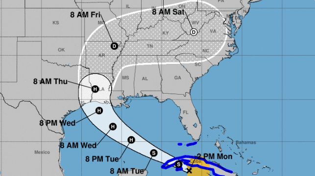
Tropical Storm Marco is expected to make landfall Monday afternoon, and Tropical Storm Laura is expected to strengthen to hurricane force before it makes landfall on Thursday. Both systems are expected to bring heavy rainfall and strong winds to coastal areas, though the forecast for Marco indicates weakening force.
Hurricanes and tropical storms can be deadly - especially their flooding effects - and the U.S. Coast Guard is urging people to be prepared, stay informed and heed storm warnings.
“These systems produce incredible amounts of rainfall in short periods of time, so we are urging people in the area to remain vigilant,” said Cmdr. Mickey Dougherty, area commander for the Marco/Laura response. “Our ability to conduct rescues can be diminished or non-existent at the height of a storm, but we have our crews staged and ready to respond to emergencies immediately after each storm passes.”

USCG response boats ready for pre-storm storage at a secure site on the NASA Neutral Buoyancy Lab campus, Houston, Texas (USCG)
According to the National Hurricane Center, Tropical Storm Marco weakened overnight Sunday, and its wind intensity is currently estimated at 35 knots. The NHC expects that its tropical storm force winds will no longer reach the northern Gulf Coast, and all wind and surge warnings for this region associated with Marco (not Laura) have been discontinued.
On Monday, Tropical Storm Laura was passing off the coast of Cayo Largo, Cuba, headed west-northwest on a curving track towards Louisiana. Its sustained winds are currently estimated at about 50 knots, but it will soon pass over an area of very warm water and strengthen before making landfall in western Cuba. As it heads out over the Gulf of Mexico, it will pass over more warm seas, and conditions are ripe for further strengthening. "The regional hurricane models remain quite bullish on intensification," NHC said in a forecast discussion. "There is an increasing risk of dangerous storm surge, wind, and rainfall impacts from the upper Texas coast through the north-central Gulf Coast beginning on Wednesday."
At present, the forecast suggests that Laura will reach a maximum intensity of 90 knot sustained winds before making landfall.
Oil and gas industry prepares
The Gulf Coast's oil and gas industry is adjusting operations to prepare for the arrival of the twin storms. More than 280 production platforms have been evacuated as of Monday morning, according to the U.S. Interior Department's Bureau of Safety and Environmental Enforcement. From operator reports, BSEE estimates that more than 80 percent of the current oil production in the Gulf of Mexico has been shut in.

that matters most
Get the latest maritime news delivered to your inbox daily.
In addition, workers have been evacuated from six out of the ten non-DP drilling rigs currently operating in the U.S. Gulf. A total of 11 out of 16 DP-enabled rigs have moved off location out of the storms’ projected paths.
The Louisiana Offshore Oil Port (LOOP) - the only American terminal capable of handling fully laden VLCCs - shut down Sunday in advance of foul weather.
