Tropical Storm Intensifies Into Cat-5 Hurricane Overnight Off Mexico

A tropical storm off the Pacific coast of Mexico has exploded into a dangerous Category 5 hurricane in less than 24 hours, according to the National Hurricane Center. It ranks among the most powerful storms ever recorded in the basin, and among the fastest-forming as well - a capstone to an unusually active Pacific cyclone season.
On Monday morning, Polo was a common tropical storm with an intensity of about 45 knots. By Tuesday, following a "truly remarkable" stretch of extreme rapid intensification, it had sustained winds of 140 knots.
Hurricane Polo hasn't moved much in the past 6-12 hours, and it's doing just fine. The warm water below is deep and contains enough "climate fuel" to sustain a high-end Category 5 for much longer.
— Ryan Maue (@RyanWeather) September 23, 2026
El Niño 1997 --> El Niño 2026 ... massive hurricanes can't be stopped. pic.twitter.com/92fQXNO2o9
On Tuesday afternoon, a NOAA Hurricane Hunter flight measured an extreme low pressure of 892 mb at the center of the storm and flight-level wind speeds of about 168 knots, with surface-level winds assessed "conservatively" at a powerful 155 knots. It was hovering over one patch of warm water, its drift assessed at just one knot.
NHC forecasters predict that the hurricane will retain most of its strength for days, fueled by "extremely warm" El Nino waters and light vertical wind shear. The intensity forecast suggests that its wind speeds will remain above 125 knots through the 25th, and tropical storm warnings extend out as far as Mexico's western coastline. Heavy rainfall will likely have dangerous effects on shore, including flash-flooding and mudslides - and the plume of water vapor spun out by the storm is causing heavy rainfall events as far away as New Mexico, 1,000 miles to the north.
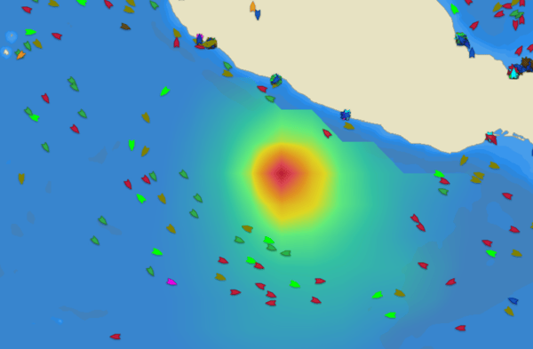
Steering forces are expected to move the hurricane to the northwest over the next several days, moving it off the coast of Baja California. The storm may briefly disrupt shipping on the lanes to and from Manzanillo, Mexico's biggest Pacific port, and force vessels on north-south routes along the coast to move further offshore. AIS data provided by Pole Star Global shows the routes that vessels have already adopted to avoid the hurricane's path, and most are giving its winds and waves a wide berth.

that matters most
Get the latest maritime news delivered to your inbox daily.
Traffic navigates around a region of high estimated wave height in the vicinity of Hurricane Polo, Sept. 22 (Pole Star Global)
Polo is the third Category 5 hurricane in the Pacific this season; its speedy expansion ranks up near Hurricane Patricia's record for most extreme intensification in a 24-hour period (a 95-knot speed gain for Polo versus Patricia's 105 knots).