Prospects for Joint Upgrades of the St. Lawrence Seaway
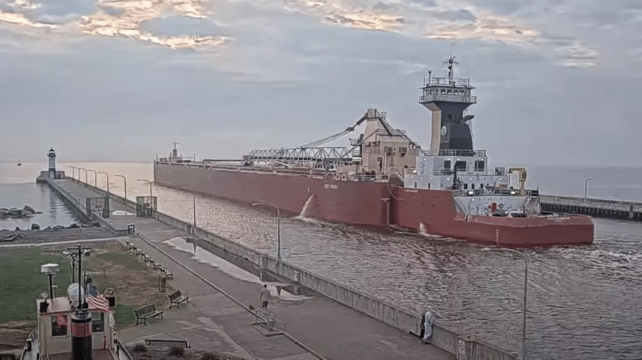
The development of the St. Lawrence Seaway and the international hydroelectric power dam east of Lake Ontario represented a milestone in international cooperation between the USA and Canada. There might be a case for further such cooperation to improve maritime productivity by upgrading the Seaway.
Introduction
The pioneers who developed transportation during the late 1700s and early 1800s in the United States and Canada recognized the cost-competitiveness of waterway transportation. They organized the digging of the Erie Canal across northern New York State, between the Hudson River at Albany and Lake Erie at Buffalo. Measurements undertaken during the 1800s revealed that, exerting equal effort, draft animals could pull up to 20 times the payload in a river barge as compared to a wagon riding over unpaved dirt paths. Teams of draft animals each pulled extended-length barges along the canal, moving massive payload at low transportation cost for that era.
Following completion of the Erie Canal, the British colonial government funded development of navigation canals between Montreal and Lake Ontario, bypassing a series of rapids along the north side of the Upper St. Lawrence River. By the mid-1800s, steam-powered ships sailed between Montreal and Lake Ontario for up to nine months of each year. Small ocean-going ships subsequently sailed between Lake Ontario and England/Europe. However, the physical size of ships increased during the late 1800s and into the early 1900s to exceed canal dimensions, preventing sailing west of Montreal.
Bigger Ships and the Great Lakes
The steadily increasing size of freight ships eventually led to discussions about international joint development of ship navigation between the North Atlantic and the Great Lakes. Those discussions resulted in the international joint development of a new navigation canal between Montreal and Lake Ontario, to transit the largest freight ships on the ocean during that era. While the United States developed the navigation locks at the power dam near Massena, NY, Canada developed a new navigation channel south and west of Montreal—west of the American locks—as well as the Welland Canal between Lake Ontario and Lake Erie.
By the late 1950s, during nine months of navigation, large ocean-going ships could sail across the North Atlantic and along the navigable waterway to the Lower and Upper Great Lakes. Waterway transportation offered lower transportation cost per ton per mile than railway transportation, especially when transporting bulk freight. It is the basis of the economic case that sustains bulk-freight maritime transportation on the Upper Great Lakes and assures feasible sailing of Seawaymax-size ships from ports around Lake Superior, carrying agricultural produce to overseas markets.
Cost-Competitive Maritime
The cost-competitiveness of maritime transportation manifests beyond the Upper Great Lakes and the St. Lawrence Seaway. Between 2008 and 2010, the Sea Point Group of New Orleans undertook a study involving transportation of containers between Long Beach and Memphis, using an earlier-generation Panamax ship that sailed via the Panama Canal. Despite a $100-per-container transit fee at the Canal, followed by transferring containers to river barge tows at the Port of New Orleans, maritime transportation incurred lower transportation costs per container than direct and quicker railway transportation between Long Beach and Memphis.
The Panama Canal was subsequently redeveloped to transit larger ships that sail between Asia and East Coast USA, and between West Coast USA and Europe, at competitive transportation cost per container and/or per ton of bulk freight. Mega-size container ships carry containers from Europe and Western Asia to the Port of Newark at competitive cost. A small ship carrying 1/16th the number of containers, sailing between European ports and the ports of Cleveland and Duluth, incurs lower transportation cost per container—the result of high railway transportation cost from Newark to Cleveland and Duluth.
Trump and Great Lakes
President Trump showed support for Upper Great Lakes navigation when, in October 2018, he signed a bill to develop a large navigation lock between Lakes Superior and Huron. The economic value of ship traffic sailing between the two lakes carrying bulk freight is estimated at nearly US$1 trillion. By comparison, the high cost of railway transportation of the same tonnage and volume of bulk freight would greatly reduce the economic competitiveness of industries located across the Eastern and Central USA that depend on delivery of that bulk freight at competitive transportation costs.
Bigger Ships on the Seaway
A technical precedent on the Upper Great Lakes involves the operation of tug-barges by the Van Enkevort Tug & Barge, with barges built to identical dimensions as Seawaymax ships. The tug removed engines, fuel tanks, and crew accommodation from the ship, increasing barge payload capacity beyond that of Seawaymax ships. Leaving navigation unchanged at the locks between Lake Erie and the Port of Montreal, there will be a need to extend the length of the navigation locks to transit extended-length tug-barges capable of sailing between the Upper Great Lakes and the Atlantic Ocean.
There is a precedent of tug-barges carrying bulk freight along the American east coast, west coast, and the body of water between Florida and Texas. Tug-barges that sail the Upper Great Lakes frequently encounter ocean-size waves and should be able to carry low-priority bulk freight at competitive transportation costs between Upper Great Lakes American ports and East Coast American ports. Despite the high cost of the Canadian flag that hampers domestic Canadian waterway transportation, tug-barges would likely be able to carry iron ore at competitive transportation costs from the eastern end of the St. Lawrence River to Hamilton.
Waterway Competition
While Mississippi River barge-tow navigation extends from New Orleans to Chicago and Duluth, the largest barge tows sail between New Orleans and St. Louis. Shorter and narrower barge tows sail north of St. Louis. The Mississippi system is far more prone to drought and flooding; as a result, navigation can still occur along the St. Lawrence Seaway when sections of the Mississippi are subject to navigation restrictions.
During periods of low water levels along the St. Lawrence River, tug-barges involving Seawaymax-size barges would carry greater payload than self-powered Seawaymax ships and maintain operational feasibility. A large tug-barge sailing the St. Lawrence Seaway with extended-length navigation locks would be cost-competitive between the Upper Great Lakes and East Coast ports, including New York City.

that matters most
Get the latest maritime news delivered to your inbox daily.
Conclusions
Extended-length vessels based on proven technology, carrying 25% to 40% greater payload and sailing the St. Lawrence Seaway between the Great Lakes and the Atlantic Ocean, offer long-term economic benefit to both the USA and Canada. Such vessels could carry iron ore pellets from Duluth to Philadelphia to support operation of industries located across Eastern Pennsylvania, or bulk agricultural produce to any of several east coast American ports.
The opinions expressed herein are the author's and not necessarily those of The Maritime Executive.