Australia's Port Hedland Cleared as Largest Cyclone in a Decade Nears

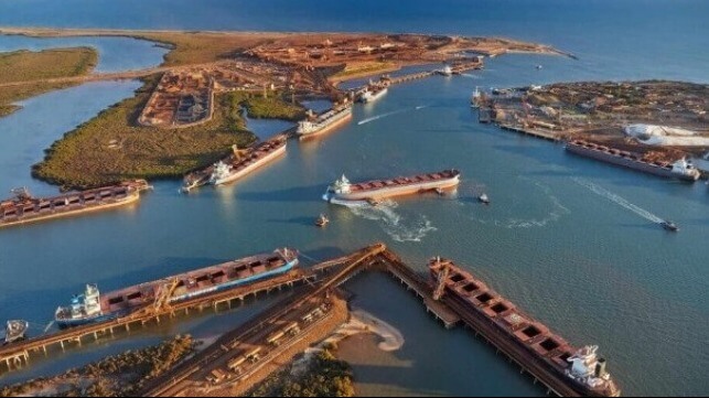
The Port of Port Hedland in northwest Australia issued an order for all ships to clear the port and its anchorage as they prepare for what is expected to be the strongest cyclone to hit the region in at least a decade. The world’s largest ore port is preparing for the potential impact coming late in the week as government officials are warning the region that the late-season storm could bring utter devastation.
“A severe impact is likely along the coast and adjacent inland parts between Port Hedland and Broome, during late Thursday or early Friday,” the government’s official meteorological service is warning. “During Friday, Ilsa is forecast to maintain tropical cyclone4 intensity as it tracks further inland across the northern interior district.”
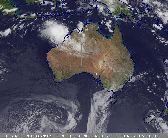
The cyclone season ends during April and while storms are common along the northern coast this one is coming late in the season and further to the west than typical. It is currently moving in a southwesterly direction remaining just off the coastline already impacting shipping in the region. The Bureau of Meteorology’s current forecast track shows the storm continuing to move in the same general direction through late on Wednesday or early Thursday when it is expected to turn south and then tack a sharp turn back to the east. By the afternoon of April 13, it is expected to become a four 4 cyclone and roar ashore northeast of Port Hedland.

The cyclone is expected to hit the port and mining region late on Thursday or early Friday
Warnings are calling for at least 24 hours of gale wind with watches extending for up to 48 hours. The official forecast calls for “very destructive winds” sustained between 55 and 100 mph as it reaches the coast. A spokesperson for the bureau however has warned that gusts could exceed 150 mph. Currently, the winds are extending out 80 nautical miles from the center of the storm with ships in the region already being warned to extreme precautions and report in the weather conditions at three-hour intervals. The weather service is also warning of “abnormally high tides,” and heavy rainfall with some areas expecting at least 7 to 8 inches of rain from the storm.
Tuesday morning, April 11, the Port of Port Hedland reported that they were beginning to implement their emergency plan while the storm was still reported to be more than 250 miles north of Broome.
“Pilbara Ports Authority will start clearing vessels from the Port of Port Hedland inner harbor from 0200 tomorrow (Aril 12) on high tide,” an alert informed mariners. “All port anchorages with the Port of Port Hedland boundary have been cleared.”
The hope is that the port will avoid a direct hit but on the current track it would be still exposed to strong winds. Port officials are warning that the seas could reach 13 to 16 feet in the bay. The port was scheduled to close as of 18:00 on April 11 and they are currently saying it will likely be closed until late on Friday, April 14, or possibly longer depending on the level of damage.

that matters most
Get the latest maritime news delivered to your inbox daily.
Port Hedland is the world’s largest ore port used by companies including BHP and Fortescue while Rio Tinto operates from the nearby Port of Dampier. In February 2023 alone, Port Hedland reported over 240 vessel arrivals and over 39 million tons of ore shipped including copper, iron, manganese, and salt.
Officials are fearful that the track of the storm could also take it directly through some of the prime mining regions. Everyone in the region is being warned to prepare and take precautions. The flooding threat is greatest for the mining and inland regions. Additional emergency service works, supplies, and vehicles are also being brought into the region in the hours before the expect the first bands of the storm to begin reaching the region.
