On World Oceans Day, Global Fishing Watch Unmasks Global "Dark Fleet"

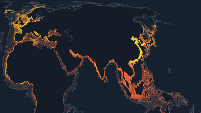
AIS tracking partnership Global Fishing Watch has expanded its reach with what it believes to be the first ever publicly-available worldwide map of "undetected dark fleets" - vessels that do not broadcast AIS.
Using synthetic aperture radar (SAR) data from the European Space Agency's Sentinel-1 satellites, coupled with machine learning algorithms, Global Fishing Watch has figured out how to automatically track vessels without the use of satellite AIS. By analyzing the entire archive of Sentinel-1 radar imagery, Global Fishing Watch has isolated 20 million data points showing the movements of sea-going vessels over about 30 feet in length. It matched up these radar returns to 100 billion GPS position data points from vessels broadcasting their position over AIS. By correlating the two, the NGO's system is able to track many vessels even after they "go dark" and attempt to evade detection.
“It is surprising how little we have known to date about the true scale of human activity on the water,” said David Kroodsma, director of research and innovation at Global Fishing Watch. “If you combine vessels that intentionally shut off their signal with the significant number of boats that don’t make their whereabouts known in public systems at all, you end up with gaps in data, monitoring and accountability. We are using satellite radar imagery to reduce that information gap and put our findings at the fingertips of those who want to ensure our ocean is managed equitably and sustainably.”

that matters most
Get the latest maritime news delivered to your inbox daily.
The organization has used this technique before to aid its investigations, like the stunning discovery of intensive Chinese fishing activity off the coast of North Korea - the largest known case of illegal fishing by an industrial fleet in another nation's waters. The organization's new public portal for SAR data is open to all, and it provides a radar-informed "heat map" for vessel presence and vessel fishing behavior. It does not allow the user to track individual vessels in the manner of publicly-available AIS databases. For researchers, however, Sentinel-1's data stream holds many possibilities - well beyond illegal fishing.
“By seeing and characterizing the activity of these expansive dark fleets, we can begin to better understand and quantify not just illegal fishing but a great deal of human activity that is impacting our marine environment,” said Paul Woods, chief innovation officer at Global Fishing Watch. “These are exciting times when it comes to open, accessible data that anyone can use for free to understand and advocate for the fragile marine areas they care about most.”
