
IMO Authorizes New Bering Sea Routing
The IMO adopted a joint proposal by the U.S. and Russia on Friday for a series of connected vessel routes and precautionary areas in adjacent Bering Sea and Arctic waters. The IMO’s Navigation, Communications and Search and Rescue Sub-Committee gave final authorization during an eight-day meeting in London.
The eastern Bering Sea is a relatively shallow body of water with average depths ranging from six to 75 meters. These shallow depths offer minimal under keel clearances compared to the waters surrounding the western Aleutian Islands and North Pacific Ocean where offshore water depths are well over 900 meters in depth. The shallow depths of the eastern Bering Sea are especially problematic for mariners because some nautical charts for this area are based on hydrographic data obtained over 100 years ago with a leadline at spacing intervals in excess of a mile apart.
The new measures are a culmination of years of analysis and consultation, informed by the U.S. Coast Guard’s Bering Strait Port Access Route Study. The new shipping lanes will help vessels steer clear of treacherous sea features in the Bering Sea and Bering Strait areas. Areas to be Avoided have been nominated which will ensure that ships bypass culturally and ecologically important coastal waters and, in the event of a vessel power failure, provide valuable time for assistance to arrive.
These protective zones will be established around Nunivak Island, St. Lawrence Island and King Island. While all of the measures are voluntary for domestic and international ships, there is a high rate of compliance with IMO-sanctioned routing measures such as these. Studies have found compliance rates for recommended routes and Areas to be Avoided to be up to 96 percent and 97 percent, respectively.
The new protections are expected to come into effect early next year - ahead of what is expected to be a 100 to 500 percent increase in vessel transit by 2025.

that matters most
Get the latest maritime news delivered to your inbox daily.
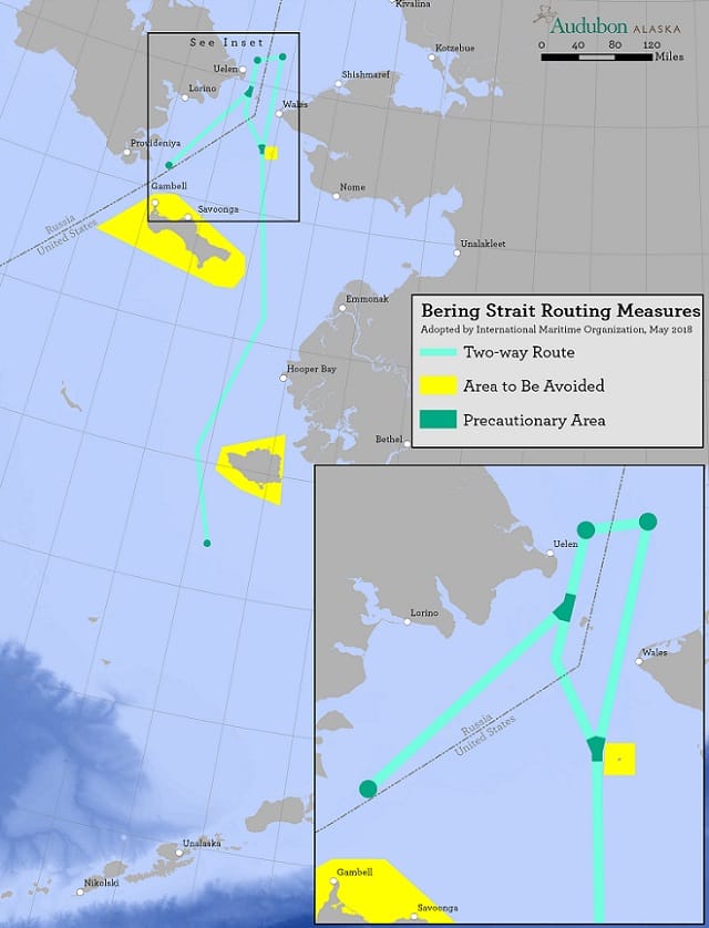
Map credit: Audubon Alaska
