
Florida's Gulf Coast Ports Prepare for Tropical Storm Ian
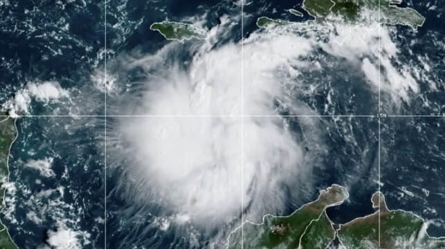
Ports across Florida are bracing for the approach of Tropical Storm Ian, which is expected to curve to the north and make landfall on the state's Gulf coastline on Thursday. The National Hurricane Center predicts that it will become a major hurricane over the waters of the eastern Gulf of Mexico, though wind shear may degrade its intensity before it arrives in Florida. It is expected to produce "significant wind and storm surge impacts across portions
of the Florida west coast and the Florida panhandle," the center warned.
Uncertainty about Ian's track and intensity is higher than usual, NHC warns, and the storm could affect a wide swath of the coastline. Even if the storm weakens just before it makes landfall in Florida, "we could see a situation where we have Cat 4 storm surge and potentially a Cat 1 or 2 hurricane landfall,” Director of Florida Division of Emergency Management Kevin Guthrie said Sunday.
The Captain of the Port for Sector St. Petersburg has set Port Condition X-Ray in anticipation of high winds within 48 hours. The warning covers the ports of Tampa, St. Petersburg, Manatee and Ft. Myers, and it requires large merchant vessels to prepare for departure or obtain Coast Guard permission to remain in port.
The Captain of the Port for Miami has issued a similar warning, mandating reduced container stacking heights for box storage and requiring large merchant ships to make preparations for departure.

that matters most
Get the latest maritime news delivered to your inbox daily.
Key West, which is first in line to feel the effects of the storm, is getting ready earlier. Vessels as small as 300 GT must get ready to depart by 2200 hours on Monday, and the port is already closed to inbound commercial traffic. The Keys have no "safe haven" ports for vessels to weather out hurricane-force winds.
After evaluating the storm track, emergency management officials for the Florida Keys have determined that there is no need to order an evacuation for the general population, as the center of the storm is forecast to pass well to the west.