The Rising Threat to the Integrity of Maritime Navigation Data

Loss of satellite signal is a well-known operational risk, but few mariners are aware of the threat of GNSS providing a false time, position or direction even when still available. When these position errors exceed a safe margin of error, they can cause ships to derive and transmit dangerously misleading Information. GNSS is not designed with inherent real-time integrity, which refers to the users’ ability to trust the data and receive timely warnings if it is unreliable.
So-called space-based (SBAS) or ground-based (GBAS) augmentation systems provide information about the accuracy, integrity, continuity and availability of GNSS services. The European Union’s EGNOS program is a prominent example of an SBAS solution. The UK’s recent exit from the EGNOS program means that, although users will still be able to receive EGNOS signals across the UK, they will have no access to the assurances provided by the future EGNOS Safety of Life services - effectively withdrawing assured system level integrity for EGNOS, GPS and Galileo.
Mariners may therefore be unaware of subtle signal degradation or position, navigation and timing (PNT) errors that exceed a safe alert limit, rendering any threats to signal integrity less visible - and therefore even more dangerous than signal outages.
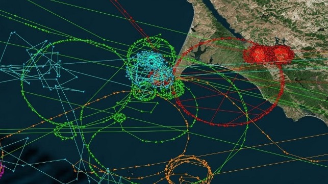
GNSS trustworthiness is under increasing threat from natural signal interference, deliberate jamming, "spoofing," or interception. The scale of the threat was highlighted by research in 2019 showing thousands of ships affected by spoofing incidents around the busy port of Shanghai. Three hundred vessels had their GNSS locations replaced by false coordinates in a single day. One container ship’s GPS units, AIS transponder and even its emergency distress system were all affected, and its true position and speed were falsified without the user being alerted to the fact, illustrating the extent to which relying on PNT data without adequate integrity protection can form a single point of failure across all maritime navigational aids.
There are many reasons for this kind of erroneous data. While some ships may nefariously "clone" the AIS systems of licensed vessels or interfere with their own GNSS receivers to conceal illicit activities, erroneous position reports can occur for any vessel. Onboard or land-based systems can produce accidental interference with GNSS receivers, for example. Misleading data can also come from natural causes, such as space weather, which poses a recurring risk of low-level signal degradation and interference. So-called "black swan" space weather events such as the 1859 Carrington event could trigger electromagnetic storms that would cause severe global disruption.
Discrepancies between GNSS and a ship’s radar picture cause can confusion, and are dangerous in areas of dense, complex traffic and poor visibility. At worst, they can even lead to vessels migrating dangerously off course and into the path of obstacles.
This issue will be further exacerbated on autonomous vessels, where decision-making is based on artificial intelligence and conflicting inputs will be difficult to resolve. Moreover, modern navigation systems are electronically intertwined into a mutually dependent system-of-systems, so navigational errors on a single ship will have a ripple effect across an entire fleet.
Trustworthy precision navigation is more essential than ever, with shipping lanes increasingly squeezed by the growth in the size and volume of vessels at sea, the necessary expansion of offshore windfarms, sea space designated for environmental protection, and areas dedicated to ‘blue economy’ uses like aquaculture. With global seaborne trade set to double by 2030, accurate and reliable PNT data will become even more pivotal to the safety, efficiency and reduced environmental impact of trade flows.

that matters most
Get the latest maritime news delivered to your inbox daily.
There is a strong international policy focus on resilience and availability of GNSS, and within those initiatives we must see a clear focus on ensuring the integrity and operational continuity of GNSS data. Mariners and policymakers need to recognize that lack of PNT integrity poses a growing threat to maritime safety and efficiency. The EU’s EGNOS Safety of Life alert service is a response to this for its members, and the UK government is examining potential solutions for a more resilient and trustworthy PNT system-of-systems. It is imperative that we see similar efforts worldwide so that navigational data is consistently resilient, trustworthy, accurate and available across global shipping lanes.
George Shaw is the Principal Systems Engineer for the General Lighthouse Authorities of the UK and Ireland.
The opinions expressed herein are the author's and not necessarily those of The Maritime Executive.
