After 55 Years, B.C. Cleans Up the Wreck of the MV Schiedyk
A hazardous coastline
The region stretching from Cape Scott Provincial Park on Vancouver Island in the north down to Tillamook Bay on the Oregon coast is known as the Graveyard of the Pacific for a reason. From the era of sails and sextants to the present day, this region has been a challenge for mariners to navigate due to the unpredictable weather and rocky, convoluted coastline. First Nations have been journeying up and down this same coast since time immemorial, fishing and harvesting the rich bounty from coastal areas, and trading with other Nations.
The experience of the captain of the Schiedyk (pronounced shkee-dike) proved how quickly things can go wrong. The freighter set sail on January 3, 1968, from Gold River, British Columbia, a community tucked in a fjord on the west coast of Vancouver Island, carrying a cargo of grain and wood pulp. Unable to make a critical turn due to a rudder failure, the Schiedyk struck a submerged reef off Bligh Island in Zuciarte Channel.1 The crew of 34 were successfully rescued, but after a few hours the Schiedyk slipped beneath the waves to rest on the reef.
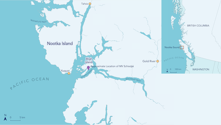
Map of Bligh Island, Zuciarte Channel, and the surrounding area.
What’s in a Place Name?
Bligh Island lies in Nootka Sound off the West Coast of Vancouver Island. When British navigator and explorer Captain James Cook arrived in a cove on the southeast side of the island in 1778, he named it for William Bligh, a Master on Cook’s vessel HMS Discovery. Bligh later gained notoriety as the captain of the HMS Bounty, whose crew mutinied in the South Pacific. Nootka was an erroneous name, the product of “often clumsy misinterpretations” by early European visitors of Indigenous names according to an account by author Andrew Scott.2 In this case, Cook is said to have believed nootk-a was the First Nation’s name, but it likely was the Nuu-chah-nulth word for “around” being used to instruct the Cook expedition on where they could safely navigate or to explain that they were on an island (itchme nutka, a place you can “go around”). The name nuu?aan?u? or Nuu-chah-nulth (“All Along the Mountains and Sea”) was chosen in 1978 to represent the First Nations along western Vancouver Island down to the northern edge of Washington State.3
After the sinking, the decision whether to undertake a salvage operation rested with the ship’s owners, Holland-America, and the insurance company, Lloyd’s of London.4 They decided that a salvage operation wasn’t economical and the freighter was written off as a wreck, absolving the owners and insurance company of any further liability. Without rules to cover the Schiedyk, the vessel was left in an ambiguous regulatory area when the oil from ship’s fuel tanks, known as bunker oil, began to leak. Today, the polluter-pays principle and Canadian law require shipowners to take responsibility, but at the time, the owner and insurance company were able to walk away leaving a leaking wreck with no plan to clean up the spill.
Fuel continued to leak between January and May 1968, although no accurate account exists of the amount of oil that escaped from the ship’s fuel tanks. Oil spill clean-up efforts to recover the bunker fuel were performed by the Ministry of Transport, the forerunner of today’s Transport Canada. While pressure was applied to Holland-America to take responsibility, they took no action. The wreck appeared to stop leaking and at some point, it slipped off its resting place on the reef, rolling upside down before settling at a depth of more than 100 metres with an unknown quantity of fuel still on board. Lost to the sea, the submerged wreck rested quietly for decades, and — significantly — memories of the incident began to fade.
A mystery sheen appears 52 years later
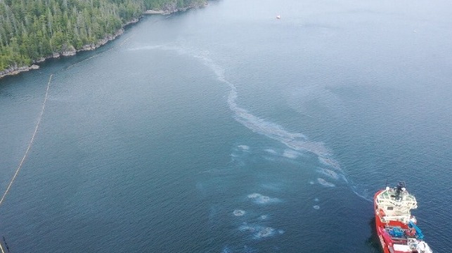
In mid-September 2020, an oily sheen appeared on the surface of the water in Zuciarte Channel between the south side of Bligh Island and the north side of Vancouver Island.
Over the next weeks, reports of small releases of between 30 to 50 litres of oil at any given time continued coming into the Canadian Coast Guard from a concerned public. The Coast Guard labelled it as a mystery spill – a spill with no known source. At first, it was believed that the sheen on the water was caused by a bilge-discharge from modern-day vessels. However, further reports from the public made everyone realize that the problem was something more serious. The Schiedyk had long since sunk and as many of the area’s residents had moved or died, the sinking was no longer in the community’s collective memory. Finding the origin of the oil was a challenging process.
By December 2020, as larger amounts of oil continued to leak, the Coast Guard identified the area’s historical wreck, the Schiedyk, and traced the source, discovering the wreck itself using a remotely operated marine vehicle (ROV). Greg Walker, who served as the federal incident commander in the subsequent clean-up, explained the process in an interview in the Ha-Shilth-Sa newspaper.5
Oil spill clean-up begins
In a typical oil spill emergency response, an Incident Command System is used to allow different agencies and teams to work effectively together with clearly defined responsibilities. The virtual Incident Command Post (due to the pandemic) was staffed by personnel from across Canada, including the Canadian Coast Guard, Fisheries and Oceans Canada, Environment and Climate Change Canada, the B.C. Ministry of Environment and Climate Change Strategy, and other partners and contractors whose role was to monitor the shorelines, especially sensitive areas, marine mammals, and other wildlife during the operation. As this spill occurred on the traditional territory of the Mowachaht/Muchalaht, the First Nation was integrated into the Incident Command team with a seat at the table for clean-up strategy and decision-making.6 The Incident Command team relied on the West Coast Vancouver Island Integrated Response Plan to guide the spill response.
An Integrated Response Plan guides the Incident Command team when responding to an oil spill. Prepared by the Canadian Coast Guard, it provides an operational plan for a clear and coordinated response. The West Coast Vancouver Island Integrated Response Plan, completed in May 2020, was put to use for the Schiedyk spill. This plan had provisions for the management of sensitive First Nations data to allow it to be included and interpreted for decision making, while protecting its confidentiality. The Canadian Coast Guard plans to regularly update the Integrated Response Plan for the region to reflect new insights and information.
Geographic Response Strategy proved an essential clean-up tool
Western Canada Marine Response Corporation (WCMRC) is the Transport Canada-certified response organization contracted to provide spill response for the west coast of Canada. Even though the Schiedyk was a historical wreck, WCMRC was contracted by the Canadian Coast Guard to support the government agencies in this incident with their knowledge and resources.
Clear Seas spoke to WCMRC about their role during the response. One of the key tools they applied for the Schiedyk spill response was a Geographic Response Strategy (GRS). The development of this tool came out of WCMRC’s engagement with coastal communities about their concerns related to spill response. Communities wanted to be more involved in spill response planning and they wanted the planning to be more transparent. The creation of the GRS program aimed to address these concerns.
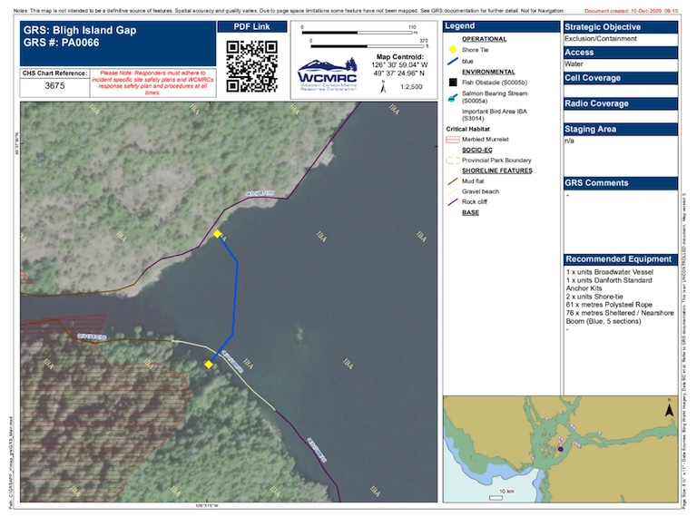
An example of a GRS sourced from WCMRC.
Creating a Geographic Response Strategy
Creating a GRS requires mapping the coastline, identifying where sensitivities are using provincial and federal data sets, and understanding culturally sensitive areas significant to First Nations. Generally, these plans are created in consultation with Indigenous and coastal communities to incorporate their deep local knowledge into the response plan. WCMRC hosts workshops and engagement sessions to get communities involved in looking at the maps to identify knowledge gaps. The GRS can keep sensitive data private, such as why a certain area needs protection, while still communicating a community’s priorities by indicating areas in high need of protection. WCMRC notes that they need to know what areas are important to a First Nation, not why, and there is no need to share sensitive data.
A GRS identifies cultural sites along with environmental and economic sensitivities, among other things, and provides a guide for action during the first 24 hours of a spill response.7 On a tangible level, a GRS is specific, providing details as to how much boom is needed, where to anchor it, how many vessels and people are needed – distilled into a one-page document. When a spill happens, a trajectory model can predict where the oil is likely to spread, then the GRS helps responders get ahead of the movement of the oil. (Explore the WCMRC’s GRS here.)
In responding to the Schiedyk spill, the GRS provided critical information to quickly identify the sensitive areas that required protection using floating barricades called containment booms.
The WCMRC had previously worked on the recovery of oil from the M.G. Zalinski, a U.S. army ship, which sank in the Grenville Channel in 1946 and was lost until 2003 when, like the Schiedyk, it started leaking bunker oil. The experience was excellent learning for the Schiedyk response.
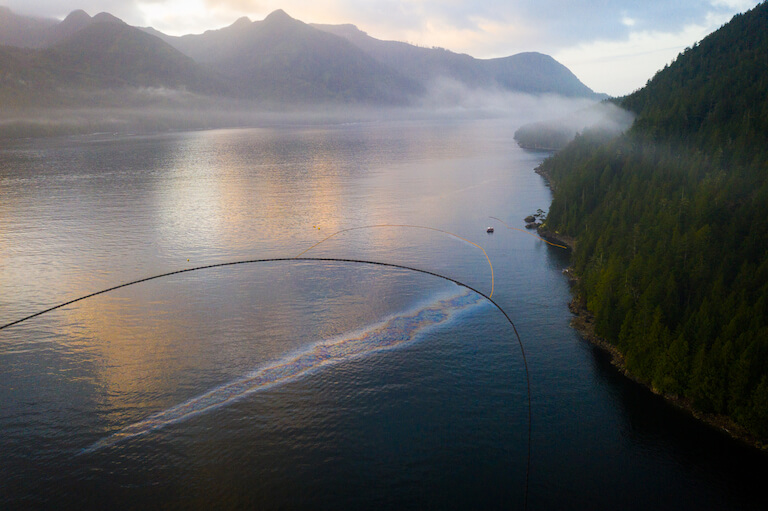
When beginning the Schiedyk response, the first goal was to prevent the oil from spreading into sensitive areas. Once sensitive areas are protected, the next goal is to get oil off the water, then clean up beaches, but in this case, oil did not reach the beach. The integration and collaboration with the Coast Guard and Mowachaht/Muchalaht First Nation was key, according to WCMRC spokesperson Michael Lowry, Senior Communications Manager. “It takes a lot of people to be successful,” he said. Many spill responders point to the recovery rate of oil as a measure of success, however, Lowry says that the type of oil spilled is a big factor in how much product can be retrieved. WCMRC’s first measure of success is always: “is it a safe operation, did we keep everyone safe?”
First Nations are consulted but important lessons remain for the future
The Nuu-Chah-Nulth Tribal Council (NTC), a not-for-profit that provides a wide range of services to the 14 Nuu-chah-nulth First Nations, spoke to Clear Seas about their involvement in the clean-up.
An NTC spokesperson felt the engagement with First Nations showed improvement, with a lot of back-and-forth communication out of a desire to “involve more people rather than less.” Cultural sensitivities relating to ecological and archeological sites in need of strong protection were identified by Mowachaht/Muchalaht First Nation elders, with their concerns taken seriously.8 According to an NTC spokesperson, being integrated into the unified command structure allowed Indigenous perspectives and knowledge to be prioritized. However, the Nations expressed concerns that while they can play a key role, they don’t necessarily have the resources and tools to map their territory.
A noted area for improvement was the follow-up to an initial spill report. Once a call is made to a spill response phone line, the next steps are unclear. Who is responsible for following up or taking action? In the case of the MV Schiedyk, once the Canadian Coast Guard began to investigate further, they contacted the NTC to ensure they were aware of the situation.
Another factor limiting full community involvement was the COVID-19 pandemic. While the response team tried to involve the surrounding communities as much as possible, the pandemic health restrictions required caution. Both the Coast Guard and WCMRC asked the Nation how they might participate to identify ways to make meaningful connections with the community. One way was through economic benefits; the response organizations stayed locally and ate locally. The WCMRC emphasised that the community connection was important, and a sign of a successful response.
The timing of the response work required responders to work through Christmas and New Year’s Day. Michael Lowry from WCMRC noted that being away from family during the holiday season can be tough; however, responders emphasized the appreciation they received from the community. On Christmas morning, responders coming to get breakfast at the Moutcha Bay Resort where they were staying were surprised to find Christmas stockings lined up for them with small gifts, candies, and notes thanking them for their work in protecting the area. Chief Jerry Jack from the Mowachaht/Muchalaht First Nation also thanked responders for their work.
The NTC spokesperson said that this clean-up effort showed improved engagement with communities despite the challenge of the pandemic, allowing for the relationship between Indigenous peoples, the Coast Guard, and other agencies to continue to develop.
Specialized salvage resources required
While efforts were ongoing to clean the oil from the water, the source of the leak still needed to be addressed. For this, the federal government contracted Resolve Marine based in Ft. Lauderdale, Florida, who were tasked to remove the oil from the vessel supported by Canadian subcontractors. The project was divided into two phases. The first phase involved surveying the site using remotely operated vehicles (ROVs) that create a picture of the situation including mapping the hull.
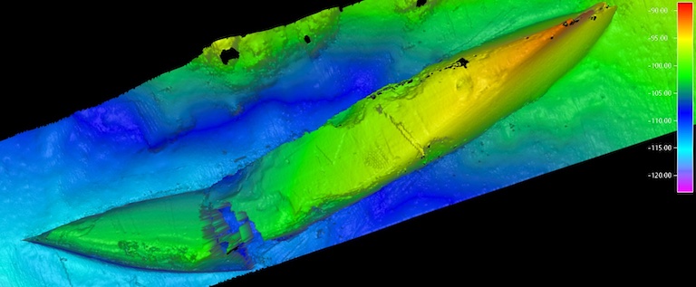
Sonar Image of the upside-down hull of the MV Schiedyk. Source: Resolve Marine.
Once the assessment was complete, the second part of the operation – oil removal – could begin. ROVs drilled holes into the vessel’s four fuel tanks. The Coast Guard explained that the ROVs secured a drainage valve with a hose attached for pumping operations. To remove the heavy fuel oil, hot water was injected into the tanks to liquefy the oil. The oil and water mixture was then pumped to the surface through the hoses to be collected onboard the offshore support vessel, the Atlantic Condor, where the oil and water were separated. The Schiedyk’s tanks were then flushed until fuel was no longer detected. According to Resolve Marine, approximately 61.5 cubic metres of oil were recovered and delivered ashore for proper disposal.
Attitudes and laws have changed since 1968
According to the April 2022 federal budget some $33 million was spent on the Schiedyk clean-up.9 In part, the cost was due to the emergency nature of this response. Addressing abandoned, derelict vessels and historical wrecks, and their oil leaks, while an expensive undertaking, can be less costly when the recovery is planned. The legal system in place when the Schiedyk sank had no requirements for ship owners to clean up oil, so the oil was simply left in the wreck and the ship owner walked away.
Today, the Canadian system is based on the polluter-pays principle and compensation is provided by the Ship-source Oil Pollution Fund (SOPF) if the polluter is unable to pay. In the case of the Schiedyk, the SOPF does not cover the clean-up costs because the vessel sank in 1968, prior to the SOPF’s creation. Although a similar grounding is much less likely today, thanks to technology like automatic identification and global positioning systems, sonar, radar and improved weather prediction, should a commercial vessel like the Schiedyk run aground, the ship’s operator would be required to address the spill when the accident occurred. They could not simply walk away as they did in 1968.
How many historical wrecks remain?
The Canadian Coast Guard is compiling a list of vessels of concern: wrecked, abandoned, and hazardous vessels, both above and below the water. Vessels are prioritized based on several criteria including pollution risk. Under the Oceans Protection Plan, there is a process for the public to report wrecked, abandoned and hazardous vessels. Vessels on the surface understandably attract the most attention because they are a visible reminder of the risk they pose, but there are many vessels lurking under the water as well.
In May of 2019, Canada acceded to the Nairobi International Convention on the Removal of Wrecks (2007), which sets out international regulations on the effective removal of wrecks.10 In addition to providing funding for the clean-up or removal of vessels of concern, the Wrecked, Abandoned or Hazardous Vessels Act aims to prevent further vessels of concern in Canadian waters by tightening the rules to prevent vessels from being abandoned.11
Wrecks in Other Waters
In 2013, National Oceanic and Atmospheric Administration (NOAA) in the United States completed a risk assessment of the estimated 20,000 sunken wrecks in US waters. This initiative was launched when oil leaks from a sunken wreck in San Francisco led to a major recovery effort, similar to the Shiedyk. The resulting RULET database was used to assess 87 wrecks and identify 36 that posed the largest threat of pollution. The data supports US Coast Guard decision-making on proactive oil recovery. It also speeds up the identification of so-called mystery spills. For example, oil was recovered in 2019 from a sunken World War II tanker near Long Island, New York after a leak was discovered.
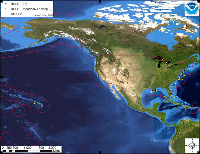
The locations of the 87 wrecks addressed in the US national risk assessment. Source: NOAA.
In Canada, work is underway to develop a database on historical wrecks and their risk of pollution. According to the NTC spokesperson “there is a lot of fear” around how many other shipwrecks are out there, especially after the Schiedyk. “Where is the list, which ones could be dangerous, how could we assess this?” the NTC asked. More transparency and collaboration with communities is needed around what wrecks the federal government is aware of, “does anyone know, is there a plan to salvage them, and who will pay for this?” – and what do they intend to do to protect coastal waters from other historical wrecks.
This article appears courtesy of Clear Seas and may be found in its original form here.
References
1 The Captain’s Account of the Sinking. (January 5, 1968). Daily Colonist.
2 Andrew Scott, The Encyclopedia of Raincoast Place Names, A Complete Reference to Coastal British Columbia, Harbour Publishing, (2009) pp. 429-430.
3 Nuu-chah-nulth (Nootka). (2006). The Canadian Encyclopedia.
4 Wrecked cargo ship begins leaking oil 52 years after it sank in B.C.’s Nootka Sound. (2020). CBC.
5 Oil removed from Nootka Sound shipwreck. (2021). Ha-Shilth-Sa.
6 Coast guard, First Nations work to contain oil leak from decades-old shipwreck in B.C.’s Nootka Sound. (2020). CBC.
7 WCMRC Strategies. (2023). WCMRC Website.
8 Wrecked cargo ship begins leaking oil 52 years after it sank in B.C.’s Nootka Sound. (2020). CBC.
9 Tax-exempt sperm and 8 other weird and wonderful highlights from federal budget 2022. (2022). National Post.

that matters most
Get the latest maritime news delivered to your inbox daily.
10 Addressing Wrecked, abandoned or hazardous vessels. (2022). Government of Canada.
11 About The Wrecked, Abandoned or Hazardous Vessels Act. (2019). Government of Canada Transport Canada.
The opinions expressed herein are the author's and not necessarily those of The Maritime Executive.
