
QPS Adds Direct FarSounder Integration to Qinsy
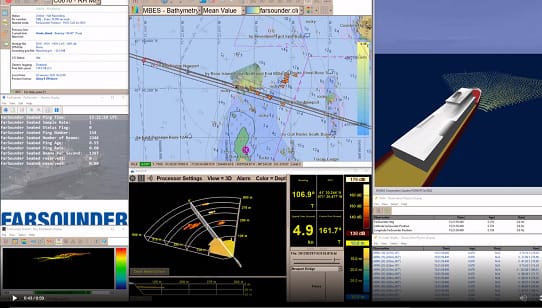
Quality Positioning Services (QPS), the experts in maritime geomatics software and services, has integrated FarSounder’s Argos Forward Looking Sonars (FLS) into their Qinsy survey software package. Argos sonar users are now able to display their FLS bathymetric data in the Qinsy platform along with the rest of the survey data they are capturing.
QPS’s hydrographic software products are used by a variety of commercial and scientific survey vessels along with many militaries around the world. Their customer the Royal Netherlands Navy recently installed FarSounder’s Argos 1000 sonars on two of their latest upgraded vessels. The navy was an intrical part in seeing this integration come to fruition. The ability for the Royal Netherlands Navy and other survey vessels to include this data in the Qinsy platform will provide valuable information during their missions.
“The ability to stream data from FarSounder's sonars into Qinsy will allow operators to not only use their Argos systems to navigate in real-time, but also monitor bathymetry and detected hazards in Qinsy,” said Heath Henley, Ph.D, FarSounder’s Hydrographic & Advanced Solutions Specialist. “Users will now be able to incorporate bathymetric data collected using FarSounder's forward looking capability into their workflow.”
By definition, surveyors venture into unknown waters. It will be a unique asset to have the ability to explore the area they are about to survey and check for hazards in real-time. At the same time, importing the target and bathymetry data into Qinsy to use as a guide when later performing the high resolution survey. With this integration into the QPS ecosystem, FarSounder data can now be included into the full survey data workflow.
The products and services herein described in this press release are not endorsed by The Maritime Executive.
