
National Hurricane Center Adds New Forecast Elements for Mariners
The National Hurricane Center is now providing several new experimental weather forecast elements for mariners that travel the open oceans of the tropical North Atlantic, the Caribbean Sea, the Gulf of Mexico, and the tropical eastern North Pacific.
The Tropical Analysis and Forecast Branch (TAFB) of the National Hurricane Center (NHC) continues to work toward improving services for the “Blue Water” mariner well away from land. Toward that goal, TAFB is introducing new experimental weather forecast elements via our Marine Graphical Composite Forecast map. While this is internet-based and not necessarily available to everyone offshore, it is designed to help any mariners in port who may have limited access to the internet, such as relatively low-bandwidth wifi provided in many remote marinas and ports. The new weather elements have been added to the existing set to help keep mariners informed and safe.
These new experimental weather elements are available via the existing TAFB’s Marine Graphical Composite Forecast maps:
Gulf of Mexico, Caribbean Sea, and Tropical North Atlantic:
https://www.nhc.noaa.gov/marine/forecast/enhanced_atlcfull.php
Tropical Eastern North Pacific:
https://www.nhc.noaa.gov/marine/forecast/enhanced_epacfull.php
The new experimental weather forecast elements include the following:
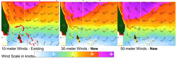
- 30-meter (~100 feet) and 50-meter (~165 feet) Winds:
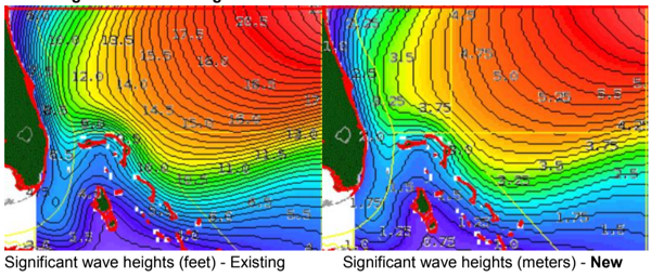
- Significant Wave Heights in meters:
- Cumulative Maximum Winds over five days (10-meter winds):
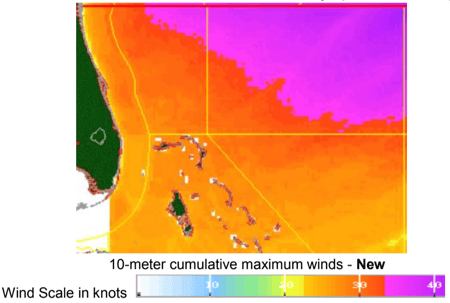
The 30 and 50-meter winds are being provided - in addition to our standard (10 meter or ~35 feet) surface winds - to aid extremely large vessels (such as cargo and cruise ships) that have heights above the water level significantly more than 10 meters. Significant wave heights (i.e., the average of the highest one-third of waves measured from trough to crest) in meters has been added to those already being provided in feet, as most “Blue Water” mariners report seas in meters and receive forecasts in meters around the world. Finally, the cumulative maximum wind provides a one-image snapshot of the strongest winds that the mariner may encounter over the next five days.
These new images are available for five pre-set domains over the tropical North Atlantic, Caribbean, Gulf of Mexico, and tropical eastern North Pacific at 12-hour forecast projections out to five days, except for the cumulative maximum wind which covers the entire 120-hour forecast period.
The products and services herein described in this press release are not endorsed by The Maritime Executive.
