
Coastal Routing Optimization - The Missing Part
By Tero Ilus, Director, Nautical Consulting at Eniram
In a previous post, I stated that coastal routing is as vital part of voyage optimization as weather routing. Almost all the ocean legs start with coastal routing and cruise traffic, and feeder traffic is almost fully coastal. I also stated that in costal traffic fuel saving potential is on average of five percent. But how is that possible? Many of us (even me before starting to take a closer look) think that there is nothing to optimize in coastal traffic.
Interestingly, it is almost equal how many vessels are avoiding the ECA area too long and how many are cutting in too early.
In coastal voyage planning there is a lot of different things to consider; shallow waters, currents, traffic, dual fuel, sewage discharge, all kind of restrictions (e.g. Particularly Sensitive Sea Areas) etc. So route planning is not an easy task. And route planning is not only putting waypoints to the chart. Making full route plan easily takes several hours. This usually leads to following misbehavior:
• The route plan is done by the vessels junior officer who does not have the knowledge of the common practices in different sea areas (or the balls to cut the corners)
• Only minimum time is taken to become familiar with the challenges of the upcoming route, and therefore the route is drawn the easiest way
• There are no real calculations done on how much different options cost. Even the simple facts are not clear to many of the officers. For example, increasing the distance by five percent means an increase in time of five percent. Yes, that’s clear, but if the estimated time of arrival (ETA) cannot be changed, the speed increase will change the fuel usage by 15 percent.
• If the leg has been sailed before, the old plan is just copied without thinking if the old plan was the most effective one or if conditions have changed since
What are the actual mistakes then? By combining Eniram’s databases and my knowledge on navigation I could easily find some common reasons. To see the full gravity of the issue, I made a heuristic model to spot the reasons in our cruise vessels data. I compared how other tracks in the same leg differ from the best sailed track in our records. So the baseline is not some theoretical track but one that a cruise vessel have been sailing. For this study, I calculated only the tracks where the speed was higher than 10 knots and the potential against best sailed would be more than one percent.
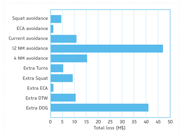
Figure 1: Total cost of the different routing mistakes in Eniram’s cruise fleet
SQUAT (SQUAT AVOIDANCE & EXTRA SQUAT)
When going around a peninsula or other shallow area it is not easy to say how much should be cut through the shallow area. The cost of squat is vessel and speed dependent and thus calculating when impact of the added distance versus vessel’s squatting is not easy. The study shows that mistakes are done in both ways. Some more vessels tend to sail in too much squat.
ECA AREAS (ECA AVOIDANCE & EXTRA ECA)
In some sea areas there is a possibility to play with the ECA-area. For example Florida’s coast gives “nice” different entry points. Also, when starting a crossing vessel can sail straight out from the ECA area and then set course to the great circle route. The change in fuel prices changes the optimal ECA entry point and makes it more difficult.
To my slight surprise playing with the ECA does not give too high potential. Of course not all of the cruise vessels are sailing in ECA areas. Interestingly, it is almost equal how many of the vessels are avoiding the ECA area too long and how many are cutting in too early.
CURRENTS (CURRENT AVOIDANCE & EXTRA DTW)
In many sea areas the currents (sea or tidal) play vital role in routing. In theory the current routing should be easy – find the shortest distance through water. But simple current routing is as good as the forecasts. And as everyone paying attention in the forecasts knows – they are newer 100 percent right. Deviating from the shortest (over ground) route is always a gamble. What if the forecasted current is not where it should be? Then the vessel is making longer route for nothing. Current routing should be done like risk management – estimate the risks and benefits, minimize the risks and make a bailout plan.
The study shows that the ships are chasing currents almost as much as missing the currents. The total potential is quite high, showing that much can be improved in this area.
DISCHARGE AREAS (12NM & 4NM AVOIDANCE)
Now, it was not a surprise to me that the biggest reason for non-optimal coastal routing in cruise vessels is the staying more than of 12 NM from the shore. But it still amazes me. Why do vessels with modern sewage treatment plants need to go outside 12NM? Why they need to sail outside 12NM for the whole leg as discharge takes only a few hours? Why do so many officer claims that they cannot do it while their colleagues in similar vessels can?
I might be wrong and I will probably get quite a lot of comments about this, but in my opinion the reason mostly is laziness. It’s too much work to communicate properly with the environmental officer and ECR on how to optimize the discharge operations for the route and not vice versa. I also hear complaints about the rest times of key people. Well, if it would save $10,000 a week maybe some arrangements could be made…
There are many reasons but rarely a good one. Mostly these are simply poor voyage planning.
Of course the risk of not completing the discharge in time needs to be taken into consideration, but simple planning on how to minimize the extra sailed distance due to discharges (with safety margins) rather than just sailing the whole leg outside 12NM from shore would make considerable savings for many of the vessels.
MEDIEVACS, STORM AVOIDANCE ETC (EXTRA TURNS)
In medical evacuations the fuel consumption loses its relevance and the route is changed to reach evacuation point as quickly as possible. Therefore, in the study these are separated in to their own category.
With heavy weather in coastal routing (especially in passenger vessels) weather routing is more storm avoidance. And by this I mean that revenue becomes more important than the fuel consumption. In most of the cases there is not enough sea room and the legs are too short to sail into different weather without adding too much distance to compensate for the weather. But saving the cargo or customer satisfaction by avoiding the storm area is more beneficial.
EXTRA DISTANCE (EXTRA DOG)
In the study the second highest potential is caused by simply sailing significantly longer distance than the best colleagues without difference in the factors above. They have sailed the same amount outside 12NM, in the same currents and shallows etc. So why?
that matters most
Get the latest maritime news delivered to your inbox daily.
There are many reasons but rarely a good one. Mostly these are simply poor voyage planning. The good thing is that it’s easy to fix. In some cases the explanation is to avoid high density traffic areas. Then, other alternatives need to be considered. Is an extra lookout enough? Or even rising the bridge to the yellow zone? How much does this cost in comparison to a poor route?
In short the route planning in coastal waters is not straight forward task, and there is a lot to improve. But how to improve it? Many of the vessels sail happily thinking that it’s the best route they sail – this is how they have always done it, and there is no better way. All the routing optimization systems (that I know) do not help with discharge or TSS areas. And only some with currents and ECA. Extra distance is easily added to the route by placing unnecessary limits on the voyage. I think we have a solution. Stay tuned for the next post…
The opinions expressed herein are the author's and not necessarily those of The Maritime Executive.