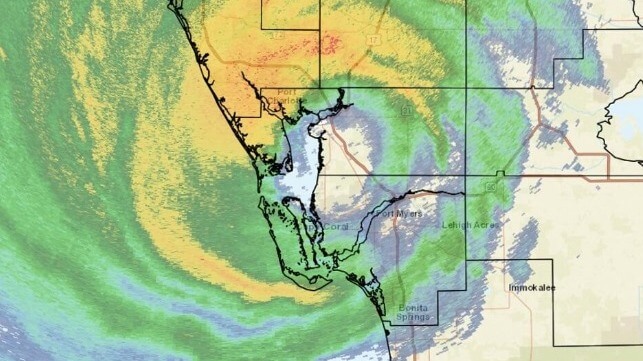
Hurricane Ian Hits Florida's West Coast

Hurricane Ian rapidly intensified into a high-Category 4 storm shortly before making landfall near Fort Myers, Florida on Wednesday afternoon, exceeding earlier intensity forecasts by a substantial margin.
The storm brought sustained winds of 155 mph and storm surge of up to 12 feet to areas of Southwest Florida, and some coastal communities are expected to sustain "life-threatening" and "catastrophic" effects, forecasters predicted. Waters pushed towards the beach by onshore winds are expected to be highest in the storm's southeast quadrant, the area south of Naples.
.@NOAA’s #GOESEast satellite captured this extraordinary imagery of #Hurricane #Ian making landfall near Cayo Costa, Florida this afternoon.
— NOAA Satellites (@NOAASatellites) September 28, 2022
Latest: https://t.co/0wCH4mn6NI#FLwx https://t.co/FX10iDGu4H pic.twitter.com/01tbXjdgZh
NOW - Ian makes landfall in Florida as a Category 4 hurricane.pic.twitter.com/UkPXgZZuoI
— Disclose.tv (@disclosetv) September 28, 2022
Powerful storm surge southern tip Pine Island FL eye wall Hurricane Ian @accuweather @ChrisFLTornado pic.twitter.com/Osn1u5kpa4
— Reed Timmer, PhD (@ReedTimmerAccu) September 28, 2022
In Tampa Bay, where initial forecasts suggested a direct hit and a devastating storm surge of 5-10 feet, the hurricane's changed trajectory and high intensity have had the opposite effect. Ian's outer northern wind field pulled water out of the bay, subtracting about a foot from low tide. This "negative storm surge" is potentially dangerous, as a wind shift can cause the water to come rushing back, and officials warned the public to stay off of unexpectedly open and exposed tidal flats. To add to this warning, the bay could still see a storm surge of 4-6 feet as the hurricane passes by.
The water has been sucked back from the coast line in Tampa Bay. pic.twitter.com/NnlAuaMUiZ
— Darla Shine (@DarlaShine) September 28, 2022
Ian is expected to pass between Fort Myers and Tampa on a northeasterly trajectory, weakening as it approaches Orlando. The likeliest track suggests it will pass directly through Orlando's suburbs with sustained winds of about 60 knots, then head out to sea on a northbound trajectory. That course will take it past Jacksonville and Mayport Naval Station, an important hub of civilian and military maritime activity.

that matters most
Get the latest maritime news delivered to your inbox daily.
Warships stationed at Mayport are under orders to sortie in advance of the storm or to secure their moorings if they must remain in port. Jaxport, the Port of Jacksonville, has been closed by order of the Captain of the Port. All vessels of 500 GT or over have been ordered to leave or obtain permission to moor safely. The port will remain closed until after Ian passes and the Coast Guard determines it is safe to reopen.
Cruise operations have also been disrupted. The Carnival Elation, which was scheduled to return to Jaxport, will extend her current itinerary until after the storm and will cancel a planned departure on September 29. Other vessels with affected itineraries include Norwegian Getaway and Disney Wish, both homeported in Port Canaveral.
