
British Antarctic Survey Tests Drones for Ocean Sensing in Antarctica
The British Antarctic Survey (BAS) has announced remarkable success in the initial testing of a new autonomous drone in Antarctica. Developed by the UK drone maker Windracers, the ULTRA (Uncrewed Low-Cost Transport) platform could be another major addition to BAS’s scientific capability in the frozen continent. If successful, it offers potential to do more science at a lower cost, with a lower carbon footprint compared to the traditional crewed aviation.
The trial for the UAV (Unmanned Aerial Vehicle) began early this month at the UK’s Antarctic research station, Rothera, jointly supervised by BAS and Windracers. Over the last few weeks, the UAV flew over 450 miles collecting scientific data, which could broaden scientists’ scope on how Antarctica is being affected by environmental change.
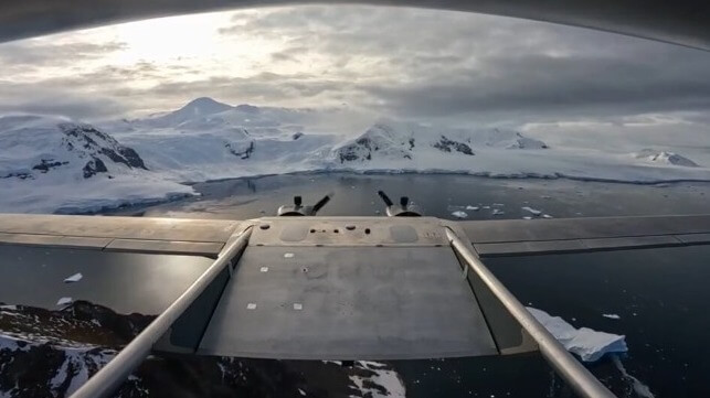
POV: you're an autonomous drone flying over Antarctica
— British Antarctic Survey ???? (@BAS_News) February 22, 2024
Over the last few weeks, the @Windracers ULTRA drone has flown more than 720km as part of tests to see if it can collect high-quality scientific data.
The verdict - so far, so good!https://t.co/QVNoThcpf7 pic.twitter.com/rpPLk1uHAO
The UAV is a fully autonomous, twin-engine, 10-meter fixed-wing aircraft, capable of carrying 100 kilos of cargo or sensors for up to 600 miles. The drone also incorporates a high level of redundancy, and can continue to fly even if one of the engines or components is damaged or fails, according to the manufacturer.
Further, it can take off, fly and land safely with minimal ground operator oversight thanks to its autopilot system, developed by Distributed Avionics.
“So far so good, everything has very much gone to plan and the Windracers ULTRA has shown that it can robustly gather a range of science data. Our initial flights have been up to 1.5 hours long with even longer missions planned in the next couple of weeks,” said Carl Robinson, Head of Airborne Survey Technology & UAVs at BAS.
Airborne surveys are used for a range of science disciplines relevant to polar science, including climate science, glaciology, geology and the study of ocean ecosystems. Under this season’s testing phase, the Windracers ULTRA will be deployed to survey protected environmentally sensitive areas and assess krill populations using cameras. Another activity is to assess ice sheet structures using airborne radar.

that matters most
Get the latest maritime news delivered to your inbox daily.
Currently, BAS undertakes many of its aerial surveys using Twin Otter aircraft. While the Twin Otters operate under an intense logistics and science regime during the field season, the drones could enable dramatic increases in flight time and geographic coverage. They would also yield reduction in CO2 emissions per flight hour of around 90 percent.
With further research, multiple drones could be deployed as a single unified system using AI-driven swarm technology.