
Data Standard Brings Enhanced Safety and Commercial Opportunities
As many will already know, S-100 is the new International Hydrographic Organization (IHO) Universal Hydrographic Data Model. Profiled from the ISO 19100 series of Geographic Information Standards and a much broader foundation to eventually replace the existing IHO S-57 standard, S-100 has been designed to quickly and easily be extended to better accommodate digital hydrographic data exchange and other future technological and navigational developments.
 S-100 now supports imagery and gridded data, high-density bathymetry, and dynamic under keel clearance management in ECDIS, in addition to many other maritime data applications. Thanks to this, the standard will enrich the next generation of data products for hydrographic, maritime shipping, and geographic information system communities.
In a navigation context, S-100 will enable improved safety of life at sea functions and promote enhanced situational awareness through the provision of a richer granularity of bathymetric data, in combination with tidal height data, which will dynamically adjust depth in ECDIS. From a navigational perspective, what this means is that numerous different digital data sets and overlays will be available to bridge teams to enhance all stages of the passage planning and execution process.
In the future, digital layers will replace multiple nautical publications, which in combination with weather forecasting will support enhanced passage optimization and Just-In-Time arrival. Whilst S-100 in its current guise is designed for humans to read and interpret on an ECDIS, because S-100 standards are fully extensible it can accommodate future requirements that may arise through developments in Maritime Autonomous Surface Ships (MASS).
The future digital data products being designed for MASS will look very different from those used today in ECDIS, as ENC data is very deliberately designed, filtered, and managed to avoid overwhelming the user with too much information. This helps to give the mariner only the correct information needed to support safe navigation decisions. However, in the future, MASS systems will be capable of handling very large, complex data sets which are not intended for mariners and other end users to visually interpret. This will present new, and exciting, challenges linked to data formats and delivery of new MASS navigation products.
Steering the development of the S-100 standard for MASS
Through our work with the MASS community, the UK Hydrographic Office (UKHO) recognised the need to ensure that the S-100 standard caters for both crewed and uncrewed shipping so a common situational awareness and navigation picture can be used across both types of vessel.
We presented this case to understand the requirements for MASS navigation to the IHO. The organization has established a Project Team with a two-year remit to identify and prioritize MASS navigation requirements, analyze the impact on the S-100 hydrographic standards and services, and develop a set of recommendations to be addressed by existing Working Groups.
Chaired by the UKHO, the Project Team has membership from Brazil, Canada, China, Denmark, Finland, France, Iran, Japan, Norway, Rep of Korea, Sweden, UK, US, Singapore & Malta. The Project Team has concluded a discovery phase which involved engaging with MASS builders, operators, and system integrators around the globe to understand the challenges the industry face with navigation from a traditional product or service perspective. This resulted in 45 new requirements for MASS navigation that will now be examined against each S-100 standard to identify if the requirement has been met in the development of S-100, or if there is a gap in the individual standards. If gaps are identified, the project team will make a number of recommendations to the relevant Working Groups to address the gap, thereby future proofing S-100 for MASS navigation.
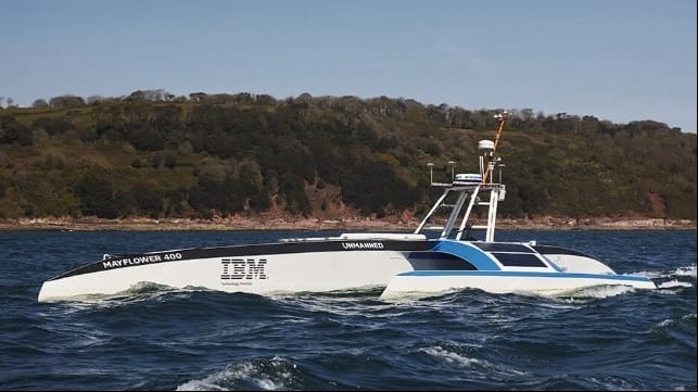
Mayflower Autonomous Ship – practical application of S-100 for MASS
As part of its work investigating MASS navigation requirements and specifically how S-100 may address them, the UKHO has been working closely with Marine AI, the team that built the navigation systems used in the Mayflower Autonomous Ship project based in Plymouth, UK.
When Mayflower set sail across the Atlantic on 28 April 2022, the vessel navigated out of Plymouth Sound using UKHO S-100 data, a world-first for a fully autonomous vessel and S-100. We then conducted experiments to look at how S-101 (ENC), S-102 (gridded bathymetry), S-104 (gridded surface water levels), and S-111 (gridded surface currents) could be used to safely sail an autonomous vessel.
The S-100 data was loaded into the Mayflower’s chart data server, which allows the autonomy modules to extract relevant information and make navigation decisions. The combined S-102 and S-104 data allowed the Mayflower to easily obtain temporal-based water depth information and generate ‘no go’ areas. The S-111 data proved essential in restricted and dynamic water space, such as the Cattewater and the narrows leading into the river Tamar. Overall, the S-100 data sets increased reliability and data quality - specifically related to depth sampling - and resulted in significant computational cost savings using S-101 over S-57.
The bigger picture
As a complete series, S-100 promises to bring new opportunities for day-to-day shipping operations, generating the potential for safer, more sustainable, and more prosperous trade. At the same time, more accurate, harmonious data will improve decision-making in passage planning, vessel operations, and support, and overall ‘smart steaming’ by taking advantage of prevailing conditions such as tides, weather, and port infrastructure - including the availability and readiness of berths, pilots, and tugs. This is how S-100 will enable more refined voyage optimization and Just-In-Time arrival, playing a pivotal role in supporting global shipping decarbonization goals.
These exciting advancements in S-100 will be instrumental in improving marine navigational data and the products and solutions that shipping companies, mariners, and ports will use in their operations in the future.
Rear Admiral Rhett Hatcher is the National Hydrographer & Deputy Chief Executive of the UK Hydrographic Office.
The opinions expressed herein are the author's and not necessarily those of The Maritime Executive.
