Tobago IDs Tug and Barge in Oil Spill as Search for Missing Tug Continues

Officials in Tobago announced that they have identified a tug that is believed to have been moving the barge that later capsized causing the national emergency and still growing oil disaster onshore and in the Caribbean Sea. The information is similar to an independent investigation that determined it was an articulated tug and barge system that foundered with the barge coming to rest upside down lodged on a reef just offshore at the southwestern end of the island.
The Ministry of National Security reports that its Coast Guard has reviewed video footage, satellite images, and other material, as well as working with multiple agencies and others including the Guyana Coast Guard. As a result, they identified the tug which is missing at this point as well as revised their earlier reports to say the capsized vessel is an unpowered fuel barge that was being taken to Guyana.
They believe the tug Solo Creed (registered in Tanzania) operating out of Panama was towing the barge named Gulfstream. The tug had departed Panama in January and made a stop in Aruba and according to the Trinidad and Tobago Coast Guard satellite images showed the tug towing an object approaching the area around Tobago on February 4. They were able to track the vessel into the country’s territorial waters, but eventually lost radar contact with both vessels. The oil slick and capsized vessel were first spotted on February 7.
The Equasis database lists the owners of the tug as unknown. They show the vessel as being built in 1976 but list it under a former name of Margie V. The tug was reported sold in the summer of 2023. TankerTrackers.com has been successful in finding satellite images of the two together and identifies the tug under the alternate name of Ranger, using the same IMO ID number of 7505994.
This may well be one of the last available images of the vessel GULFSTREAM, which capsized off the coast of #Tobago. It was photographed by @planet just 2-3 days prior to the catastrophic #oilspill. The vessel was towed by RANGER (7505994). Thank you @bellingcat for clues! #OOTT pic.twitter.com/IPxuNMdkSJ
— TankerTrackers.com, Inc. (@TankerTrackers) February 14, 2024
The authorities in Guyana confirmed that the tug and barge did not arrive as anticipated. Officials in Tobago continue to work with the various agencies and international authorities to locate the tug and its owners.
They are reporting that the identity of the tug was further confirmed through consultations with the authorities in Panama and Aruba. The Dutch authorities in Aruba were able to provide images of the tug towing the barge which was used to confirm the identity of both vessels. They are saying that there are “distinctive markings” on the capsized barge to confirm its identity.


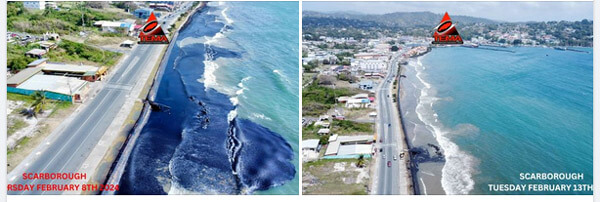
Images of the ongoing clean-up over the past few days in Tobago (Courtesy of TEMA)
The announcement came hours after the website Bellingcat which represents independent researchers released an extensive analysis identifying the barge. They pointed out unique elements such as “pigeonhole ladders on the side of the hull,” which they noted are only found on this type of unpowered barge. They concluded it was a 60,000 bbl double-hulled barge, although noted that because of the lack of detailed registrations for barges, it is difficult to track.
The authorities also released new images showing progress with the onshore cleanup while reporting that the satellite images from today, February 14, showed the slick spreading. Winds up to 14 knots and currents are driving the slick but also keeping it offshore. They estimated the slick measures 78 nautical miles and has traveled up to 63 nautical miles including nearly 20 miles outside the Trinidad and Tobago EEZ.
In addition to receiving help from volunteers, companies operating in the country are contributing resources. BP is reported to have provided equipment including remotely operated vehicles to help in the cleanup. Booms also continue to be deployed in an attempt to prevent the oil from reaching shore.

Progress according to the authorities in the onshore clean-up (TEMA)


that matters most
Get the latest maritime news delivered to your inbox daily.
Map based on this morning aerial survey showing the spread away from Tobago (TEMA)
