
Talos Energy, U.S. Coast Guard Respond to Spill off Port Fourchon
The U.S. Coast Guard is working with Houston-based oil company Talos Energy to respond to a large spill off the coast of Port Fourchon, Louisiana.
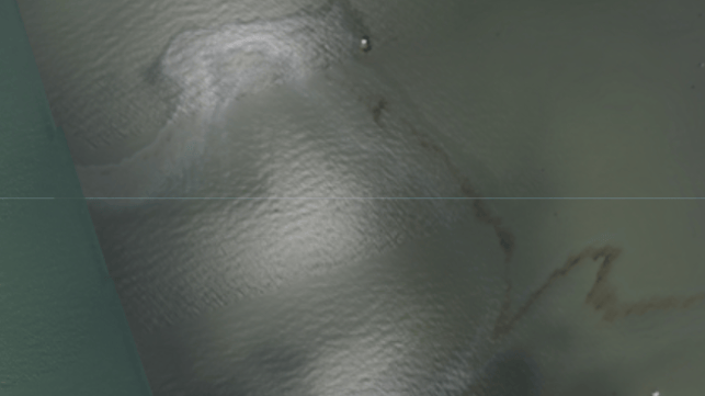
The slick was first identified by the Associated Press using satellite photographs provided by NOAA. The agency has published a full set of high resolution imagery of some of the key areas hit by Hurricane Ida last week, including Port Fourchon. The slick is clearly visible to the east of the port's approaches.
Port Fourchon is a receiving hub for offshore oil and gas pipelines, and the seabed just off its coast is a maze of pipe networks. One of the operations in the vicinity of the spill used to belong to Talos, which produced oil from a field nearby until 2017. The Coast Guard initially suggested that Talos bore responsibility as the operator, but the firm denied involvement, saying that it had plugged its wells and removed the associated pipelines by 2019. Still, Talos called in two spill response vessels and a dive support vessel, and cleanup operations are under way.
On Sunday, Talos said that its divers had inspected the site and identified the source of the leak as a ruptured 12-inch-diameter pipeline, which had been pulled out of its trench. Talos said that it is not the owner of the line, and it is working with the Coast Guard and other regulators to identify the responsible party. Like most of Louisiana's near-coastal waters, the area's oil and gas deposits have been in active development for decades, with multiple operators working in the same region.
Talos said that the rate of the spill appears to have slowed over the weekend, with less visible oil on the surface. No shoreline impacts have been reported to date.
NOAA satellite imaging also identified a large rainbow sheen at the Alliance Refinery complex in Belle Chasse, Louisiana early last week. In a statement, operator Phillips 66 said that the spill was contained within the refinery's grounds. A spokesman for the Louisiana Department of Environmental Quality told AP that the flooding had breached a levee at the refinery, and it is unknown how much oil might have escaped.
Lower Mississippi reopens to all traffic
The Captain of the Port for New Orleans has reopened all of the Lower Mississippi to vessel traffic, including areas previously closed due to downed powerlines.
During the storm, a high-tension powerline fell into the river next to the former Avondale Shipyard site west of New Orleans, blocking marine traffic for days. The shutdown impeded the flow of barge traffic carrying Midwestern grain to dry bulk export hubs at the Port of New Orleans, raising concerns among agribusiness interests.
Capt. Will Watson, @USCG Sector New Orleans commander, works with @EntergyLA to clear downed power lines from blocking the Lower Mississippi River - clearing the way for hundreds of millions of dollars in commerce that moves daily over this critical waterway. #USCGIda #Storm21 pic.twitter.com/XlpqI8kKhu
— USCG Heartland (@USCGHeartland) September 4, 2021
“Working alongside key federal, state, parish, city and maritime industry leaders, we’ve made significant progress reconstituting ports and waterways throughout Southeast Louisiana,” said Capt. Will Watson, the captain of the port for Sector New Orleans. “The marine transportation system in this region connects our heartland’s harvest with global markets and provides vital energy supply to our nation. We continue to support the State of Louisiana as we collectively recover from the impacts of Hurricane Ida.”

that matters most
Get the latest maritime news delivered to your inbox daily.
Some restrictions still apply. Upriver from Avondale as far as the Sunshine Bridge (mile marker 108-167), vessels are instructed to maintain their slowest safe speed when passing ongoing vessel salvage operations. Tows are restricted to six barges wide, and all vessels should keep as close to the center as possible, as there may still be sunken obstructions near the banks. Downriver, a large field of partially sunken barges is still located on the right descending bank at river miles 56-58.
Deep draft vessels on the Lower Mississipi are still restricted to daylight transit only, as aids to navigation may be out of place and storm debris and shoaling may present hazards.
