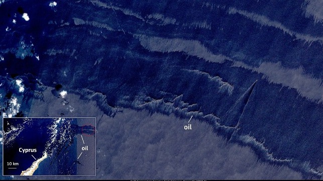
Syrian Oil Spill Threatens Cyprus' Northern Shores

A fuel oil leak from a power station in Syria has drifted across the Eastern Mediterranean, threatening shores in Cyprus and Turkey.
In the breakaway state of Northern Cyprus, which is recognized only by Turkey, officials said that they were taking action to prevent the slick from reaching scenic beaches on the Karpaz Peninsula. This included deploying a spill-response boom off the coast. Turkey, the region's external sponsor, said that it would send two spill-response vessels to assist.
An estimated 20,000 barrels of fuel oil escaped from the Baniyas Thermal Plant, according to environmental officials in Northern Cyprus. On Wednesday, reports indicated that it had approached to less than 20 nm from shore, but officials told AFP that it appeared that the prevailing winds would carry most of the slick further to the north. "The weather conditions continue to be in our favor," tourism undersecretary Serhan Aktunc told the outlet, while noting that there was still the possibility of environmental damage from heavy oil falling to the seabed.
New @ESA_EO satellite imagery shows the oil slick coming from Baniyas in #Syria on August 31st only 36km east from Cyprus coasts. Various agencies are rushing to contain the oil before it reaches the Karpas region, known for its unique ecosystems.
— Wim Zwijnenburg (@wammezz) September 1, 2021
?????Via @sentinel_hub pic.twitter.com/hsYt35r3Kb
New satellite imagery analyisis by @EOSOrbital using Sentinel-1 indicats that the #Baniyas oil spill seems way larger than anticipated, with almost 1000km2, though visual IDing is need to see if and how big the oil sheen is h/t @HarelDan pic.twitter.com/eqDK1vdD0D
— Wim Zwijnenburg (@wammezz) August 30, 2021

that matters most
Get the latest maritime news delivered to your inbox daily.
Speaking to local government-backed media, Syria's minister of electricity claimed that the size of the spill from the power plant was far smaller, in the range of just two to four tonnes. However, independent remote sensing appeared to contradict this claim. Last week, satellite imagery taken by Planet Labs on August 24 showed a long slick of oil just off the coast of Baniyas, originating at the power plant; imaging intelligence firm Orbital EOS reported Tuesday that the size of the slick had grown to about 300 square miles in the Eastern Mediterranean.
The threat may not be over yet: satellite images of the power plant taken by Maxar appeared to show a pool of black oil within a containment barrier surrounding a set of large storage tanks.
