
New Survey Technique Boosts Bird Flight Analysis
An new technique for measuring the height of birds in flight, developed by scientists at U.K.-headquartered survey firm APEM, aims to ease concerns about the potential dangers of wind turbines for birds and lead to improved outcomes for developers of offshore wind farms.
In a study late last year, a specialist survey aircraft was fitted with an ultra-high resolution Leica RCD-30 survey camera, matched with a LiDAR (light detecting and ranging) system, an advanced remote sensing method that uses pulses of light from lasers to measure the distance of objects from the sensor – in this case, the height of birds above the ground.
During the survey, the aircraft flew at an altitude of 340 meters (1,100 feet) and gathered images and LiDAR data of a swath of land 346 meters (1,135 feet) wide. As it flew, the system recorded information on features of the landscape as well as on birds in flight, both in flocks and as individuals.
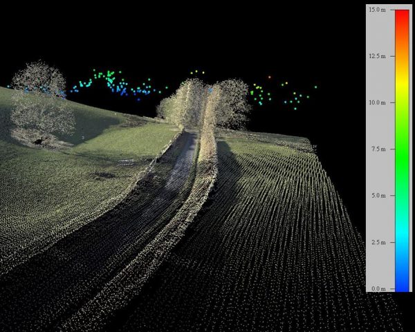
Once the data were processed into digital point-cloud images researchers were able to pinpoint the heights of birds on the wing to within five centimeters (two inches), a level of precision far greater than needed for the assessment of collision risk around wind farms.
Although the survey took place over land, a similar technique can also be used to measure the flight heights of birds at sea. APEM’s head of ornithology, Dr Mark Rehfisch, said: “A LiDAR-based approach is the future of flight height assessment in open terrain. It is very precise and accurate, it generates a permanent record, it can be applied rapidly over large areas of open habitat, and it will become increasingly affordable as the technology is taken up.”
Previous methods for measuring the flight heights of offshore birds have relied upon visual estimates from observers in boats, measurement using laser rangefinders by people stationed on offshore wind turbines, or on data from GPS tags attached to the birds.
Sophie Nunn, APEM’s project manager in charge of testing the new technique, explained: “We had already developed a way to successfully estimate flight heights from high resolution aerial images, but this approach requires the birds to be flying straight and level and this is not always the case. Our new technique is a major step forwards because it provides very precise data, regardless of the orientation of the bird.”
The earlier technique was used last year to suggest that four times fewer Northern gannets collide with wind turbines than previously thought. The study, carried out on behalf of developers Vattenfall and Scottish Power Renewables, surveyed an offshore wind farm off the coast of England using extremely high-resolution digital images.

that matters most
Get the latest maritime news delivered to your inbox daily.
Last year, APEM won a contract to carry out ultra-high resolution aerial digital surveys of offshore wildlife off the coast of North and South Carolina on behalf of the Bureau of Ocean Energy Management (BOEM). Around one million high resolution images will be captured. The area has been identified as one where offshore wind farms may potentially be built in future, and the survey will provide baseline data to help with the process of siting and permitting future developments.
APEM is also taking part in the world’s largest and most detailed offshore wildlife surveys of this kind for the New York Energy Research and Development Authority covering a 16,000-square mile area.