Drones Monitor Ship Emissions in English Channel, North Sea and Baltic

The European Maritime Safety Agency (EMSA) has resumed emission monitoring programs for ships operating within the EU Emission Control Areas in Northern Europe. Working with the French authorities, specially equipped drones are monitoring portions of the North Sea and the English Channel. In a similar effort based in Germany, they are launching a large-scale emissions monitoring campaign monitoring ships crossing portions of the Baltic.
These programs are extensions of previous efforts conducted by EMSA in collaboration with state authorities. EMSA offers remotely piloted aircraft system (RPAS) services free to all EU member states. Using specially developed systems they assist with maritime surveillance operations and ship emission monitoring, and can also provide support to traditional coast guard functions, including search and rescue and pollution prevention and response.
The program in France with the French Directorate General of Maritime Affairs, Fisheries and Aquaculture is the third emissions monitoring campaign to take place in this particular area. Remotely piloted aircraft supplied by EMSA are being used by the French authorities to measure sulfur and nitrogen emissions from ships operating in the Emission Control Area of the North Sea and the English Channel. The systems on the “sniffer drone” make it possible to check the compliance of the passing ships with rules capping the content of certain pollutants in the fuel burned.
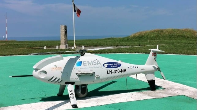
The program is operating from the MRCC for Cap Gris-Nez due to its proximity to the busy shipping lanes which are within the flight range of the aircraft in use as well as for the expertise of the personnel monitoring the maritime traffic in that area. The RPAS used is an unmanned helicopter Schiebel Camcopter S100 which is operated by EMSA’s contractor Nordic Unmanned and is equipped with an emissions sensor from Explicit that analyses the gas samples that are taken when the drone passes through the exhaust plume of the ship’s funnel or stack. Calculations are then made to determine sulfur and nitrogen levels and indications of non-compliance and can trigger an inspection at the next port of call to determine whether an infringement has taken place. Since 2020, the Schiebel Camcopter S100 drone operated by Nordic Unmanned teams has flown for more than 430 hours, over more than 600 ships, and has taken measurements from 375 merchant ships.
A similar effort is also launching in May for three months with the Federal Maritime and Hydrographic Agency in Germany. The remotely piloted aircraft will take off from the German Armed Forces' Staberhuk site on the east coast of Fehmarn and fly over selected ships operating in the Fehmarn Belt and the Kadetrinne/Kadetrenden to measure the sulfur content of their exhaust plumes using specific sensors.
The measurement systems provide real-time results which are available to the responsible authorities in all European ports from the Port State Control information system operated by EMSA. Using the information, ships can be specifically selected for inspection at their next port of call, and samples of the fuel can be taken to determine if they are in fact in violation of the strict sulfur limits placed on the region.
In the effort in Germany, multispectral aerial imagery is also being acquired. According to EMSA, for shallow waters, bathymetric values can be extracted from images and allows for three-dimensional mapping of the shore zone. The drone survey campaign will investigate whether aerial imagery can provide complementary information for the German hydrographic surveying service.
