
Astro to AI
Welcome to the 6th Generation of ECDIS
On 16th September 1620, the Mayflower sailed to the new world using astronomy.
On 16th September 2024, the 6th Generation of ECDIS sailed with AI.
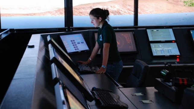
The first Generation of ECDIS was in 1979. It caused a huge shake-up in the industry and even the most cynical have since embraced the new technology. Life has never been so different for Watch Officers with charts uploaded and updated, real-time situational awareness, continuous positional information, and shipping information all overlaid on the navigational track. In short, the system allows for better navigational safety and more time available for looking out of the window.
‘6th Generation’ is another step change allowing the ECDIS to make decisions for the seafarer by automatically creating routes, defining safe water, and in the most recent iterations maneuver within the COLREGs. Dynamic squat and automatic UKC tools have also been added, with new routing charts integrated to make AI-generated route calculations more fuel-efficient for ships. The maritime industry is well on its way to Maritime Autonomous Surface Ships (MASS).
This next generation of software is being constantly developed and delivered by leading manufacturers, but, is it safe and should it be trusted?
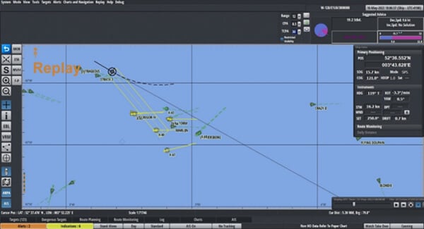
Totem Plus ECDIS System advising on COLREGs Solutions. Source: ECDIS Procedure Guide 2024 – 2025 by Witherbys
This new generation of software has affected all areas of navigation. For this article we will break it down into the four principles of Navigation, following namely; appraisal, planning, execution and monitoring, and the future.
Appraisal
On certain systems, ECDIS can define safe water by automatically interpolating between charted depths to make quick and alarmable ‘no-go’ areas. ECDIS Ltd conducted a review of this software and noted a few advantages and disadvantages.
Firstly, advantages. It is a very quick function to use, in fact, an entire port can be completed within a few minutes. The software does not miss a sounding, whereas human error can result in an isolated spot sounding being easily missed. Finally, this feature is alarmable, if the ECDIS operator makes it an alarmable attribute as well as the Safety Contour.
Secondly, disadvantages, it is not entirely clear how the software interpolates between the soundings which can give cause for concern to the cautious seafarer. It also does not apply to charted objects such as buoys or anchorage areas, which a Master would want to keep well clear of when appraising safe water prior to any passage planning. Also, if the area has few soundings due to older survey data there is no guarantee where the software will draw the line.
Having said all this, there is no doubt that automatic defining of safe water is much safer and more accurate than relying on the Safety Contour. It will allow a vessel more available safe water in which to maneuver in particularly confined areas.
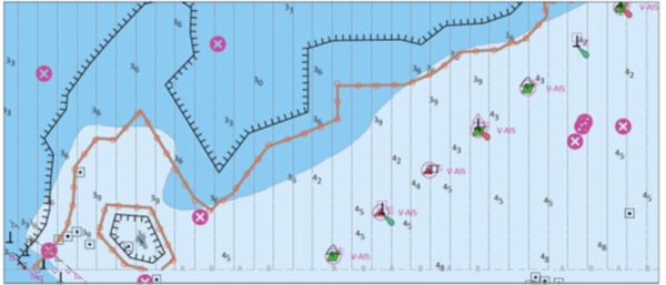
Two automatically created ‘no-go’ areas. Source: ECDIS Procedures Guide 2024 - 2025 by Witherbys
Planning
‘6th Generation’ software includes automatic and optimal route creation by ECDIS software for fuel efficiency, and, known recognized routing. ECDIS Ltd have trialed this software and found the following.
It is an extremely quick method of route creation which allows for efficient fuel calculations and ETA management. Essentially, the system optimizes the route in line with the predicted cost, provided that the ship’s information has been correctly set up in the system, comparing costs at 10 knots, 20 knots and so on. Routes can be generated between two selected ports, between associated pilot stations and between any two route points created manually. The software also ensures that boundaries are clear regarding safety contour avoidance.
However, on occasion, the automatic route can create unrealistic turns such as 90 degrees at 20 knots or pass over an aid to navigation such as a buoy (this can be regarded as an ‘aid’ rather than a ‘danger’). The plan does not account for shipping traffic such as standard ferry routes, fishing grounds, or crossing points, which would normally be taken into consideration when planned by a Watch Officer. There is no consideration for the environment or weather forecast and the planned speed is usually standard. Obviously, these issues can be overcome by manipulating the automatic route and adding the Master’s preferences.
At ECDIS Ltd a route was created on paper, on ECDIS, and by automatic ECDIS route creation software. The closest match was between the paper route and the automatic route creation software. They both had considerably less waypoints demonstrating that the automatic route creation is aligned with simple, traditional navigational methods.
Execution and Monitoring
There are numerous functions within this section that are part of ‘6th Generation’ software. The most well-known are track control systems (TCS), a more interactive ‘look-ahead’ function and predicting ships’ paths.
Track Control Systems are designed to follow a pre-planned track under various conditions within the limits of the ship’s maneuverability. A TCS works within the two parameters of the Ship’s speed from minimum maneuvering speed up to 30 knots and the ship’s maximum RoT not greater than 10° per second. Once the operator creates a planned route the ship can follow it automatically, and some of the more recent systems can calculate and correct the ship’s drift so that the ship can maintain the optimum route. When in TCS, the ECDIS operator is alerted to navigational warnings and potential dangers before the ship is at risk.
The ’Look-Ahead’ function is available on all ECDIS units, but some have new dynamic features that enable it to look around the corners. Certain manufacturers use a tidal vector from embedded tidal data software which, when selected, can be automatically used to alter the wheel over point accounting for set and drift.
The Path Predictor function, if available, allows the user to predict the heading of the ship when turning in particularly confined waters. It is normally based on Speed Over Ground, Course Over Ground, and Rate of Turn, but it is only a guide and does not replace the need to visually verify the progress of turns.
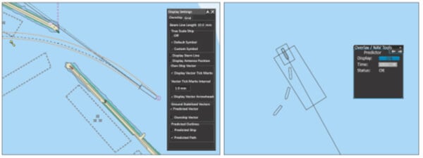
Example of Path Predictor. Source: ECDIS Procedure Guide 2024-2025 by Witherbys
Future of 6th Generation
This article has only touched on a few of the features available under this new generation of software. There are more AI options available including conning and docking software, dynamic squat, and automatic UKC.
As the 6th Generation of ECDIS software becomes more normal onboard, the ‘periodically unattended bridge’ appears to be within reach. The latest ECDIS system not only plans and follows a route automatically, but it can also adapt to various shipping scenarios, applying the COLREGs correctly whilst remaining within the limits of safe water. In 2024 the first manufacturer received full DNV approval for integrating these functions into the ECDIS software. This follows the success of the periodically unattended machinery space and paves the way to fully autonomous shipping.
To answer the question posed at the beginning of the article, this new AI-related software is safe and for the most part, should be trusted. All the training providers work tirelessly to update their courses to reflect the latest software. Recently www.eMaritimeTraining.com reported they are 85% through updating all their online courses to reflect 6th Generation software. Seafarers are naturally cautious when it comes to new technology but those that have used these new features can’t remember a world without them. They use this software every day, apply sensible amounts of caution when required, and are looking forward to what the future holds.
Debbie Hull is the Managing Director of ECDIS LTD
This article is sponsored by ECDIS Ltd. For more information please visit them online.
The opinions expressed herein are the author's and not necessarily those of The Maritime Executive.
