
Study Maps Hidden Coastal Pollution in the U.S.
Researchers have uncovered previously hidden sources of ocean pollution along more than 20 percent of America’s coastlines.
The study, published online August 4 in the journal Science, offers the first-ever map of underground drainage systems that connect fresh groundwater and seawater, and also pinpoints sites where drinking water is most vulnerable to saltwater intrusion now and in the future.
Audrey Sawyer, assistant professor of earth sciences at The Ohio State University and leader of the study, said that while scientists have long known that freshwater and seawater mix unseen below ground, until now they hadn’t been able to pinpoint exactly where it was happening, or how much, except in limited locations.
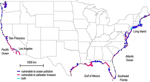
The study identified 12 percent of the continental U.S. coastline, including the northern Gulf Coast from Mississippi to the Florida Panhandle, northern Atlantic Coast and Pacific Northwest, where the once-hidden drainage systems make the ocean most susceptible to freshwater contamination from septic tanks and fertilizer runoff. There, excess nutrients in the water can cause harmful algal blooms to form and remove vital oxygen from the water. This contamination from land to sea endangers fisheries and coral reefs as well as water recreation and tourism.
In contrast, another nine percent of coastline, including confirmed locations such as Southeastern Florida, Southern California and Long Island, are especially susceptible to the opposite threat: contamination from sea to land, the study found. In these areas, saltwater intrudes inland and infiltrates the fresh groundwater supply.
“It takes only a small amount of saltwater to render drinking water non-potable, so saltwater invasion is a big concern for water resource management in coastal areas,” Sawyer said.
Among the sites on the map with the worst impacts are Los Angeles and San Francisco, which the study found to be vulnerable to both ocean contamination and saltwater intrusion simultaneously.
Overall, more than 15 billion tons of freshwater flows through invisible underground networks into the ocean along the continental U.S. coastline every year, the researchers found.
That’s less than one percent of the total amount that flows from the continental United States into the ocean. The other 99 percent comes from rivers and surface runoff.
Study co-author Cédric David of NASA’s Jet Propulsion Laboratory (JPL) says the study is significant because it provides the first continental-scale high-resolution estimate of that one percent, a portion which, when compared to the other 99 percent, can be particularly rich in nutrients and other contaminants.
Sawyer, David and James Famiglietti, also of JPL, combined U.S. topography and climate models to identify key inland regions that contribute groundwater and contaminants to the coast. They examined rainfall, evaporation rates and the amount of known surface runoff to calculate the missing portion of water that was running out below ground, and melded those results with terrain and land-use data to identify where the water ended up.
For example, precipitation is similar in the Pacific Northwest and the mid-Atlantic regions, but the study found that underground drainage rates into the ocean were approximately 50 percent higher in the Pacific Northwest because the steep terrain there carries more groundwater to the coastline.
Land use was critical to discharge in Florida, the study found, and Sawyer said that she was surprised by the big effect that canals had there.
Since the early 20th century, Floridians have constructed thousands of miles of canals along the state’s coasts for transportation, irrigation and recreation. The study found that the canals may capture water that would otherwise flow underground and out to sea.

that matters most
Get the latest maritime news delivered to your inbox daily.
The researchers commented that increased urbanization and the extensive pavement that goes along with it will also decrease groundwater recharge and ultimate draining to coastal regions where the population is growing, which increases the likelihood of saltwater intrusion.
“That’s why we hope others will use our analysis to better plan strategies for coastal land development and groundwater management that help preserve water quality,” Sawyer said. “Right now, we’ve created a map of American coastlines that highlights some previously known as well as unknown areas of vulnerability along the U.S. coastline, but we hope to be able to do it for the world shortly, as data become available.”
