
Watching Waters Rise Right Outside the Front Door
For the past two centuries, two trends have been steady and clear around the United States. Sea level has been rising, and more people have been moving closer to the coast.
As the ocean has warmed, polar ice has melted, and porous landmasses have subsided, global mean sea level has risen by 8 inches (20 centimeters) since 1870. The rate of sea level rise is faster now than at any time in the past 2,000 years, and that rate has doubled in the past two decades.
.png)
That has not stopped people from buying and building along the coast. About 55 to 60 percent of U.S. citizens live in counties touching the Atlantic or Pacific Ocean, the Gulf of Mexico, or the Great Lakes. A recent study by business and finance leaders found that $66 billion to $106 billion worth of coastal property is likely to sit below sea level by 2050.
The nation’s problem is also NASA’s problem, and not just because several satellites and hundreds of Earth scientists are monitoring the rising seas. Sea level rise hits especially close to home because half to two-thirds of NASA’s infrastructure and assets stand within 16 feet (5 meters) of sea level. With at least $32 billion in laboratories, launch pads, airfields, testing facilities, data centers, and other infrastructure spread out across 330 square miles (850 square kilometers)—plus 60,000 employees—NASA has an awful lot of people and property in harm’s way.
.png)
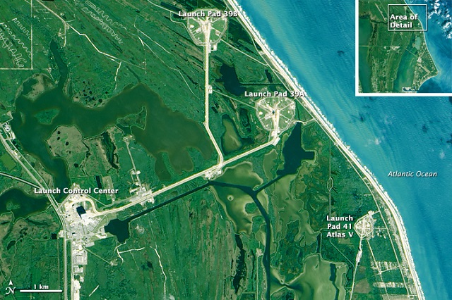
For NASA climatologist Cynthia Rosenzweig, the urgency of the problem was crystallized in the summer of 2009. As part of a climate change preparedness workshop, she joined other scientists, engineers, facility managers, and administrators on a tour of launch pads 39A and B at Kennedy Space Center. Since the Apollo-Saturn rocket days, and through 25 years of space shuttles, those two launch pads have been critical to NASA’s mission.
But when Rosenzweig got off the bus and looked around, she could see that the shrinking dunes and damaged shoreline were just a stone’s throw from the launch pads. “Every NASA center has its own set of vulnerabilities, and some are more at risk than others,” Rosenzweig said. “But sea level rise is a very real challenge for all of the centers along the coast.”
The Coast is the Place to Be
“NASA is on the coast because that’s the right place to launch from,” said Kim Toufectis, a facilities planner in NASA’s Office of Strategic Infrastructure.
The U.S. government long ago made the choice to fly most of its rockets and experimental aircraft from the coast because failures happen, and they are less dangerous to the public when they happen over water than over land. But launching from the coast requires testing, storage, and spacecraft assembly facilities to be nearby. So if you are going into space from the United States, you are going to have to face down the challenge of rising seas.
.png)
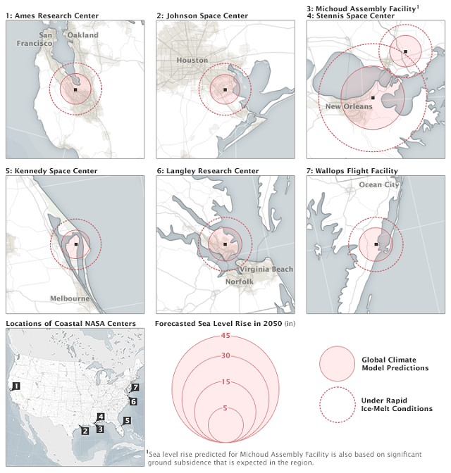
As at Kennedy, the launch pads and buildings at Wallops Flight Facility stand just a few hundred feet from the Atlantic Ocean. Langley Research Center is situated along the Back River, near the mouth of Chesapeake Bay. Ames Research Center is tucked into the south end of San Francisco Bay. Johnson Space Center sits on Clear Lake, an inlet off of Galveston Bay. Those centers all stand between 5 and 40 feet (2 and 12 meters) above mean sea level. The math is nearly upside down at Michoud Assembly Facility, which sits behind levees near the Mississippi River and Lake Pontchartrain.
In a review of the agency’s vulnerability to sea level rise, NASA’s Climate Adaptation Science Investigators (CASI) Working Group recently wrote:
Sea level rise of between 13 and 69 centimeters by the 2050s is projected for NASA’s five coastal centers and facilities…Even under lower sea level rise scenarios, the coastal flood event that currently occurs on average once every 10 years is projected to occur approximately 50 percent more often by the 2050s in the Galveston/Johnson Space Center area; 2 to 3 times as often near Langley Research Center and Kennedy Space Center; and 10 times more frequently in the San Francisco Bay/Ames Research Center area. NASA coastal centers that are already at risk of flooding are virtually certain to become more vulnerable in the future.
If you think about the height of the sea surface like the height of the water in a calm bathtub, then a rise of a few tens of centimeters over a few decades doesn’t sound like much. But sea level doesn’t rise evenly; it piles up more in some places because of natural wind and current patterns. And turbulence matters: Think about that bathtub with a child sloshing around in it. Waves can roll up one side and then the other, sometimes splashing over the brim. The higher the flat-water line, the greater the chance that the water will slosh out of the basin when it is stirred up by storms and winds.
Sea level also matters in a horizontal direction. An old rule of thumb is that one inch of vertical change in sea level translates into 100 inches of horizontal beach loss on a flat beach or marsh. In this way, a little bit of sea level rise can translate into a lot of water moving inland with storms or abnormally high tides.
“Sea level is important because it gradually moves the high-tide line farther up the beach and closer to buildable land,” said John Jaeger, a coastal geologist from the University of Florida. “It also allows storm surges to penetrate farther inland.”
Launching from a Sandbar
The high-tide line has been moving landward for some time at Kennedy Space Center on Florida’s east coast. Located within the Merritt Island National Wildlife Refuge and adjacent to Cape Canaveral Air Force Station, NASA’s most famous center covers more than 66 square miles (170 square kilometers) and holds about 20 percent of the agency’s constructed assets. Most of it is built on coastal marshland about five to 10 feet above sea level.
Conservative climate models project that the seas off Kennedy will rise five to eight inches by the 2050s, and nine to 15 inches by the 2080s. If ice sheets in Greenland and Antarctica continue to melt as quickly as current measurements indicate, those numbers could become 21 to 24 inches by the 2050s and 43 to 49 inches by the 2080s.
“We consider sea-level rise and climate change to be urgent,” said Nancy Bray, spaceport integration and services director for Kennedy.
Even as the space center was founded in 1961, management and scientists were aware that seas were rising and could someday pose a threat. But in that era, the challenge was to get to the Moon as soon as possible. There was an established Air Force station nearby with access to orbits that could not be obtained from anywhere else in the United States. The choice was easy, and it was right for the time.
But time has not been kind to this stretch of sand. Based on historical records and aerial photos, the beach in front of Kennedy has thinned and moved inland by as much as 200 feet (60 meters). The losses have been most acute and persistent along a stretch near the center’s two most prized launch pads. Complex 39A was recently leased for 20 years to Space X, which intends to use it for its Falcon heavy lift rocket. NASA’s new Space Launch System and Orion spacecraft are slotted for Complex 39B within the next decade. The Atlantic Ocean stands less than a quarter mile from both.
In 2004, three hurricanes crossed the Florida peninsula. And while none made a direct hit on Cape Canaveral, they collectively caused $100 million in damage to the space center. Then a nor’easter in 2007 sat offshore for two weeks and battered the beach; Tropical Storm Fay then raked the beach again in 2008.
In response to the persistent storm damage, Kennedy facilities managers contracted to build a 15-foot-high, 725-foot-long dune as a proof of concept for a managed retreat. Center scientists and engineers also worked with the U.S. Geological Survey to map the shape of the beach (topography) with laser ranging and detection (LiDAR). Then they enlisted coastal geologists John Jaeger and Pete Adams of the University of Florida to figure out why sand dunes near launch Complexes 39A and B were so persistently being washed away.
For five years, Jaeger, Adams, and graduate students pulled GPS mapping gear up and down 6 miles of beach at least once a month—more often in the wake of storms. The goal was to build a three-dimensional model of the area. They found that the beaches were retreating due to the shape of the seafloor just offshore, where gaps between the sandbars channel wave energy toward certain areas. But they also found sand piling up (accreting) in other areas, mostly near Launch Complex 40. The beach is migrating south, even if NASA’s infrastructure is not.
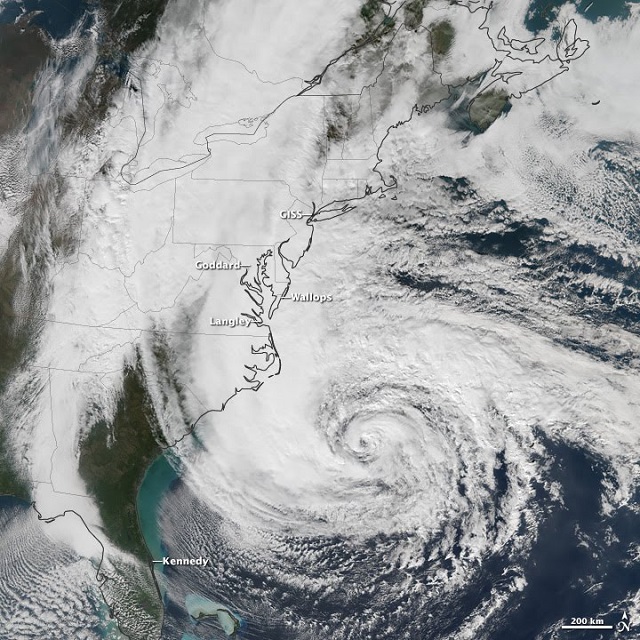
In 2012, Hurricane Sandy offered a glimpse of the new normal along the Atlantic coast. The storm passed 200 miles offshore from Kennedy, but it moved so slowly that the heavy surf scoured the beach for three or four high-tide cycles. By the time the skies cleared, the dunes along a 2-mile (3-kilometer) stretch near Complexes 39A and B had retreated as much as 65 feet (20 meters). Nearly 650 feet (200 meters) of railroad track in the vicinity of 39A were undermined by the storm surge. The high-tide line moved closer to a service road, under which lay some of the center’s natural gas, communications, liquefied rocket fuel, and water lines. That road sits just 4 feet (1.2 meters) above sea level.
Rising to Future Challenges
So what does NASA do as the seas rise around its facilities? Cynthia Rosenzweig has an answer: flexible adaptation pathways.
“What makes sense for us to do now? And what might we have to do later?” she said. “We have to consider and understand the risks, and then build something that can be adjusted.”
Rosenzweig conducts her research at NASA’s Goddard Institute for Space Studies and Columbia University, both of which stand on the Hurricane-Sandy-hardened streets of New York City. For years she worked with city and state leaders to assess the impacts of climate change and to develop risk reduction strategies. In 2009, she was asked to bring her experience to NASA’s Climate Adaptation Science Investigators Working Group, an effort prompted by a presidential order to evaluate “risks and vulnerabilities" at every federal agency.
“It may be the first time NASA’s scientists and managers have worked together to manage climate risks to our facilities and natural resources,” Rosenzweig said. Together with state and local officials—as well as federal, military, commercial, and conservation partners—CASI has set out to brainstorm what kind of information is needed by facilities managers, as well as what kind of response might be required.
The CASI team translated international reports and projections—such as the Intergovernmental Panel on Climate Change (IPCC) or the U.S. National Climate Assessment—into practical, regional-scale advice for the NASA centers. They conducted environmental impact studies and modeling to project how much sea level could rise near each facility. They examined past and future land use changes around centers, even considering how sea level rise might affect the endangered and threatened species that find havens on NASA property.
“How do we fight Mother Nature for another fifty years?” said Kim Toufectis. His colleagues at each center and in the Office of Strategic Infrastructure—people with skills in civil and chemical engineering, urban planning, real estate, facilities construction and maintenance—must now weigh their options and develop long-range plans.
In some places, they will need to design smarter buildings; in others, they will retrofit and harden old infrastructure. If a facility must stay within sight of the water, then maybe the important laboratories, storage, or assembly rooms should not be on the ground floor. For the launch facilities, which must remain along the shore, beach replenishment, sea wall repair, and dune building may become part of routine maintenance.
But across the space agency, from lab manager to center director to NASA administrator, people will have to continually ask the question: is it time to abandon this place and move inland? It’s a question everyone with coastal property in America will eventually have to answer.
By Michael Carlowicz
Source: NASA
The opinions expressed herein are the author's and not necessarily those of The Maritime Executive.
